IMAGES TAKEN NEAR TO
Rowan Drive, DURHAM, DH1 5YE
Introduction
This page details the photographs taken nearby to Rowan Drive, DH1 5YE by members of the Geograph project.
The Geograph project started in 2005 with the aim of publishing, organising and preserving representative images for every square kilometre of Great Britain, Ireland and the Isle of Man.

There are currently over 7.5m images from over14,400 individuals and you can help contribute to the project by visiting https://www.geograph.org.uk
Image Map
Images are licensed for reuse under creativecommons.org/licenses/by-sa/2.0
Notes
- Clicking on the map will re-center to the selected point.
- The higher the marker number, the further away the image location is from the centre of the postcode.
Image Listing (10 Images Found)
Images are licensed for reuse under creativecommons.org/licenses/by-sa/2.0
Image
Details
Distance
1

Minor road entering Brasside
Brasside is a small village on the outskirts of Durham city; it has the doubtful privilege of being the location of both a remand centre and a prison.
The blue and yellow road sign naming the village is in a style common in County Durham.
Image: © Trevor Littlewood
Taken: 11 Sep 2015
0.11 miles


7
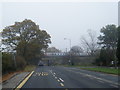
Finchale Avenue and ECML train passing over
Image: © Colin Pyle
Taken: 3 Nov 2015
0.23 miles
8
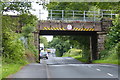
Railway bridge crossing Finchale Avenue
Image: © Mat Fascione
Taken: 24 Jun 2017
0.24 miles
9
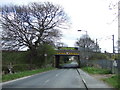
Railway bridge over Finchale Avenue
Carries the East Coast Main Line.
Image: © JThomas
Taken: 2 May 2013
0.24 miles
