IMAGES TAKEN NEAR TO
Potterhouse Lane, DURHAM, DH1 5SL
Introduction
This page details the photographs taken nearby to Potterhouse Lane, DH1 5SL by members of the Geograph project.
The Geograph project started in 2005 with the aim of publishing, organising and preserving representative images for every square kilometre of Great Britain, Ireland and the Isle of Man.

There are currently over 7.5m images from over14,400 individuals and you can help contribute to the project by visiting https://www.geograph.org.uk
Image Map
Images are licensed for reuse under creativecommons.org/licenses/by-sa/2.0
Notes
- Clicking on the map will re-center to the selected point.
- The higher the marker number, the further away the image location is from the centre of the postcode.
Image Listing (8 Images Found)
Images are licensed for reuse under creativecommons.org/licenses/by-sa/2.0
Image
Details
Distance
1
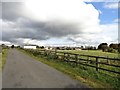
View of Kimblesworth Grange
View from the south. Kimblesworth Grange is an old farming settlement, with origins in medieval times. The present buildings are probably early 19th century. The settlement is a much older than the village of Killingworth to the north, which was established in the late 19th century for the local coal miners.
Image: © Robert Graham
Taken: 23 Sep 2019
0.03 miles
2
Gas tank at Kimblesworth Grange
A sight that's becoming increasingly familiar in the countryside. LPG seems to be taking over from oil on properties off the beaten track. Kimblesworth Grange is not remote, being only a few miles north of Durham City, but it's certainly well away from any piped gas supply.
Image: © Robert Graham
Taken: 23 Sep 2019
0.03 miles
3
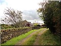
Public path around Kimblesworth Grange
The path loops around the west side of the old farming settlement of Kimblesworth Grange. This was the original settlement, dating from the middle ages, a long time before the present day village was built to the north in the 19th century.
Image: © Robert Graham
Taken: 23 Sep 2019
0.04 miles
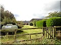
4
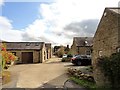
Converted buildings at Kimblesworth Grange
This old farmstead lies south of the main village of Kimblesworth. The former farm outbuildings have been converted to residential use.
Image: © Robert Graham
Taken: 23 Sep 2019
0.04 miles
5
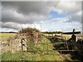
Field gateway at Kimblesworth Grange
The public path coming south from Kimblesworth village takes a sharp turn to the right here. The farm track carries on through the gateway.
Image: © Robert Graham
Taken: 23 Sep 2019
0.08 miles
6
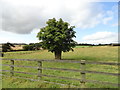
Lone tree
In a field south of Kimblesworth Grange.
Image: © Robert Graham
Taken: 23 Sep 2019
0.14 miles
7
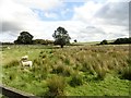
Rushy pasture
Gra.zing fields south of Kimblesworth Grange
Image: © Robert Graham
Taken: 23 Sep 2019
0.18 miles
8
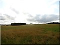
View across the fields south of Kimblesworth
Looking over the fields from beside the track leading south to Kimblesworth Grange.
Image: © Robert Graham
Taken: 23 Sep 2019
0.24 miles