IMAGES TAKEN NEAR TO
Hartside, DURHAM, DH1 5RJ
Introduction
This page details the photographs taken nearby to DH1 5RJ by members of the Geograph project.
The Geograph project started in 2005 with the aim of publishing, organising and preserving representative images for every square kilometre of Great Britain, Ireland and the Isle of Man.

There are currently over 7.5m images from over14,400 individuals and you can help contribute to the project by visiting https://www.geograph.org.uk
Image Map
Images are licensed for reuse under creativecommons.org/licenses/by-sa/2.0
Notes
- Clicking on the map will re-center to the selected point.
- The higher the marker number, the further away the image location is from the centre of the postcode.
Image Listing (5 Images Found)
Images are licensed for reuse under creativecommons.org/licenses/by-sa/2.0
Image
Details
Distance
1
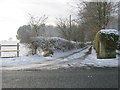
Public footpath on lane to Fyndoune and beyond
Image: © Peter Robinson
Taken: 16 Jan 2013
0.14 miles
2
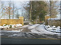
Entrance to Wellsprings Farm off the B6532
Image: © Peter Robinson
Taken: 16 Jan 2013
0.15 miles
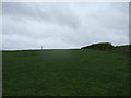
5
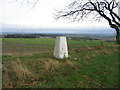
Trig Point at Fyndoune with Durham City in background
Image: © Pangula
Taken: 19 Jan 2006
0.22 miles