IMAGES TAKEN NEAR TO
Canterbury Road, DURHAM, DH1 5PX
Introduction
This page details the photographs taken nearby to Canterbury Road, DH1 5PX by members of the Geograph project.
The Geograph project started in 2005 with the aim of publishing, organising and preserving representative images for every square kilometre of Great Britain, Ireland and the Isle of Man.

There are currently over 7.5m images from over14,400 individuals and you can help contribute to the project by visiting https://www.geograph.org.uk
Image Map
Images are licensed for reuse under creativecommons.org/licenses/by-sa/2.0
Notes
- Clicking on the map will re-center to the selected point.
- The higher the marker number, the further away the image location is from the centre of the postcode.
Image Listing (13 Images Found)
Images are licensed for reuse under creativecommons.org/licenses/by-sa/2.0
Image
Details
Distance
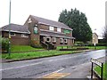
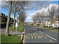
2
Finchale Road, Newton Hall
A suburb of Durham.
Image: © Oliver Dixon
Taken: 18 Nov 2010
0.08 miles
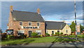
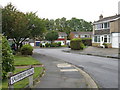
5
Canterbury Road, Newton Hall
A large, outlying suburb of Durham.
Image: © Oliver Dixon
Taken: 2 Mar 2007
0.13 miles
6
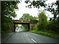
Railway Bridge near Brasside Durham
Carrying East Coast main line
Image: © P Glenwright
Taken: 24 Sep 2006
0.13 miles
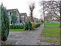
7
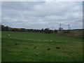
Farmland near the East Coast Main Line Railway
Image: © JThomas
Taken: 2 May 2013
0.17 miles
9
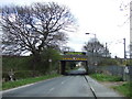
Railway bridge over Finchale Avenue
Carries the East Coast Main Line.
Image: © JThomas
Taken: 2 May 2013
0.19 miles
10
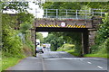
Railway bridge crossing Finchale Avenue
Image: © Mat Fascione
Taken: 24 Jun 2017
0.19 miles