IMAGES TAKEN NEAR TO
Alnwick Road, DURHAM, DH1 5NN
Introduction
This page details the photographs taken nearby to Alnwick Road, DH1 5NN by members of the Geograph project.
The Geograph project started in 2005 with the aim of publishing, organising and preserving representative images for every square kilometre of Great Britain, Ireland and the Isle of Man.

There are currently over 7.5m images from over14,400 individuals and you can help contribute to the project by visiting https://www.geograph.org.uk
Image Map
Images are licensed for reuse under creativecommons.org/licenses/by-sa/2.0
Notes
- Clicking on the map will re-center to the selected point.
- The higher the marker number, the further away the image location is from the centre of the postcode.
Image Listing (11 Images Found)
Images are licensed for reuse under creativecommons.org/licenses/by-sa/2.0
Image
Details
Distance

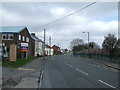
2
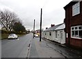
Old Pit Terrace, Newton Hall
Whilst most of Newton Hall consists of modern housing estates, there are a few old streets, like this one on Pit Lane.
Image: © Robert Graham
Taken: 17 Nov 2014
0.13 miles

5
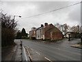
The Carrs
Old houses on Pit Lane, Newton Hall, on a murky autumn day.
Image: © Robert Graham
Taken: 17 Nov 2014
0.17 miles
7
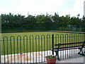
Bowling Green, Abbey Leisure Centre, Abbey Road
Image: © Ann Clare
Taken: 13 Jun 2009
0.21 miles
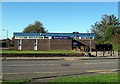
8
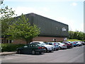
Abbey Leisure Centre, Abbey Road, Pity Me, Durham
Image: © Ann Clare
Taken: 13 Jun 2009
0.22 miles
9
Carr House Drive, Newton Hall
Looking east along this street in the large residential suburb of Newton Hall on the north side of Durham City.
Image: © Robert Graham
Taken: 17 Nov 2014
0.22 miles
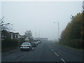
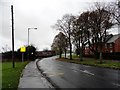
10
Pit Lane heading north
Towards Newton Grange.
Image: © JThomas
Taken: 2 May 2013
0.23 miles