IMAGES TAKEN NEAR TO
Frankland Road, DURHAM, DH1 5HZ
Introduction
This page details the photographs taken nearby to Frankland Road, DH1 5HZ by members of the Geograph project.
The Geograph project started in 2005 with the aim of publishing, organising and preserving representative images for every square kilometre of Great Britain, Ireland and the Isle of Man.

There are currently over 7.5m images from over14,400 individuals and you can help contribute to the project by visiting https://www.geograph.org.uk
Image Map
Images are licensed for reuse under creativecommons.org/licenses/by-sa/2.0
Notes
- Clicking on the map will re-center to the selected point.
- The higher the marker number, the further away the image location is from the centre of the postcode.
Image Listing (9 Images Found)
Images are licensed for reuse under creativecommons.org/licenses/by-sa/2.0
Image
Details
Distance
1
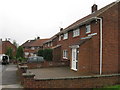
Bracken Field Road, Framwellgate Moor
Image: © Alex McGregor
Taken: 27 Sep 2010
0.09 miles
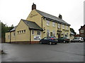
2
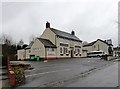
The Happy Wanderer, Priory Road
Suburban pub in Framwellgate Moor, Durham.
Image: © Robert Graham
Taken: 17 Nov 2014
0.13 miles
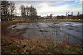
4
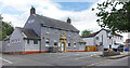
The Gate, Framwellgate Moor
On Beech Road. Another closed pub.
Image: © Des Blenkinsopp
Taken: 26 Aug 2022
0.14 miles
5
The Happy Wanderer, Framwellgate Moor
Image: © Alex McGregor
Taken: 27 Sep 2010
0.14 miles
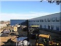
8
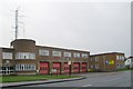
Durham fire station
Durham fire station, Finchale Road, Framwellgate Moor, Durham, County Durham
Image: © Kevin Hale
Taken: 26 Nov 2006
0.22 miles