IMAGES TAKEN NEAR TO
Suffolk Way, DURHAM, DH1 5GN
Introduction
This page details the photographs taken nearby to Suffolk Way, DH1 5GN by members of the Geograph project.
The Geograph project started in 2005 with the aim of publishing, organising and preserving representative images for every square kilometre of Great Britain, Ireland and the Isle of Man.

There are currently over 7.5m images from over14,400 individuals and you can help contribute to the project by visiting https://www.geograph.org.uk
Image Map
Images are licensed for reuse under creativecommons.org/licenses/by-sa/2.0
Notes
- Clicking on the map will re-center to the selected point.
- The higher the marker number, the further away the image location is from the centre of the postcode.
Image Listing (15 Images Found)
Images are licensed for reuse under creativecommons.org/licenses/by-sa/2.0
Image
Details
Distance
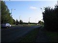
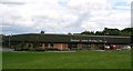
1
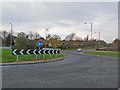
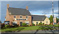
Red House Roundabout
Roundabout on the perimeter road which flanks the business parks at the northern end of Durham.
Image: © Oliver Dixon
Taken: 18 Nov 2010
0.06 miles
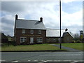
2
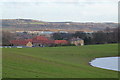
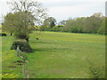
Red House Farm Newton Grange
View from footpath from Hag Farm showing the Durham escarpment on the horizon and Franklin Prison in the middle distance.Note the flooding in the fields after heavy rains- all these fields are earmarked for housing by DCC from here to Sniperley Farm.
Image: © Malcolm Coils
Taken: 3 Jan 2014
0.10 miles
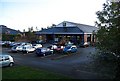
5
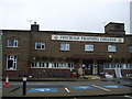
Entrance Finchale College
Originally built in 1943 to train people disabled as a result of war
Image: © P Glenwright
Taken: 24 Sep 2006
0.17 miles
7
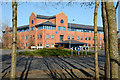
Headquarters of Northumbrian Water
The brick-built building which is the head office of Northumbrian Water is at the Arnison Centre in the district of Durham city oddly named as 'Pity Me'.
Image: © Trevor Littlewood
Taken: 12 Mar 2014
0.18 miles
9
Yet another crappy photo of nothing in particular with blurred vegetation in the foreground and faint window reflections ...
... because it was taken with no effort whatsoever from a high speed train for a grid square that I've never actually set foot in and have no particular interest in other than getting a Geograph point for it.
This is image no.317 of 1193 on the East Coast main line between King's Cross and Inverness.
I'm sorry that the window reflections aren't a bit more prominent, and that despite several attempts I was unable to include some extraneous overhead power cables in the image (there are only two tracks on this section of line - I think you need four or more tracks to get the cables in the shot).
See also Image
Image: © Mike Quinn
Taken: 1 May 2012
0.19 miles