IMAGES TAKEN NEAR TO
The Bungalows, DURHAM, DH1 5EB
Introduction
This page details the photographs taken nearby to The Bungalows, DH1 5EB by members of the Geograph project.
The Geograph project started in 2005 with the aim of publishing, organising and preserving representative images for every square kilometre of Great Britain, Ireland and the Isle of Man.

There are currently over 7.5m images from over14,400 individuals and you can help contribute to the project by visiting https://www.geograph.org.uk
Image Map
Images are licensed for reuse under creativecommons.org/licenses/by-sa/2.0
Notes
- Clicking on the map will re-center to the selected point.
- The higher the marker number, the further away the image location is from the centre of the postcode.
Image Listing (12 Images Found)
Images are licensed for reuse under creativecommons.org/licenses/by-sa/2.0
Image
Details
Distance
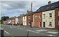
1

Terraced housing on Front Street at Pity Me
Image: © David Martin
Taken: 29 Jun 2014
0.08 miles
2
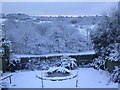
The Carrs, Pity Me, Durham UK
Winter Scene
Image: © Eric Haswell
Taken: 21 Feb 2005
0.09 miles
4
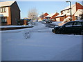
Bishops Way, Pity Me. Dec 05
Snow................December 27th 2005
Image: © Eric Haswell
Taken: 29 Dec 2005
0.11 miles
5
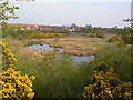
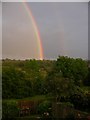
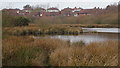
The Carrs, Pity Me, Durham UK
Nature Reserve
Image: © Eric Haswell
Taken: 24 Apr 2005
0.14 miles
7
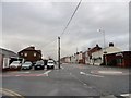
Junction Road and Front Street, Pity Me
View south down Front Street on a rather wet autumn morning.
Image: © Robert Graham
Taken: 17 Nov 2014
0.17 miles
8

Mini roundabout
Junction of Front Street and Abbey Road
Image: © Roger Smith
Taken: 22 Oct 2008
0.19 miles
10
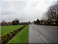
Looking west along Abbey Road
On the east side of Pity Me.
Image: © Robert Graham
Taken: 17 Nov 2014
0.22 miles