IMAGES TAKEN NEAR TO
Hudspeth Crescent, DURHAM, DH1 5DZ
Introduction
This page details the photographs taken nearby to Hudspeth Crescent, DH1 5DZ by members of the Geograph project.
The Geograph project started in 2005 with the aim of publishing, organising and preserving representative images for every square kilometre of Great Britain, Ireland and the Isle of Man.

There are currently over 7.5m images from over14,400 individuals and you can help contribute to the project by visiting https://www.geograph.org.uk
Image Map
Images are licensed for reuse under creativecommons.org/licenses/by-sa/2.0
Notes
- Clicking on the map will re-center to the selected point.
- The higher the marker number, the further away the image location is from the centre of the postcode.
Image Listing (9 Images Found)
Images are licensed for reuse under creativecommons.org/licenses/by-sa/2.0
Image
Details
Distance
1
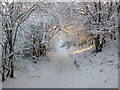
Another view of Pity Me, Durham
Photo taken on the 29th December 2005.
Walking down the path leading from the old railway line, just before you go under the A167
Image: © Eric Haswell
Taken: 29 Dec 2005
0.13 miles
4

Terraced housing on Front Street at Pity Me
Image: © David Martin
Taken: 29 Jun 2014
0.22 miles
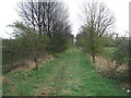
5
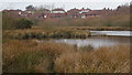
The Carrs, Pity Me, Durham UK
Winter Scene
Image: © Eric Haswell
Taken: 21 Feb 2005
0.23 miles

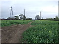
8
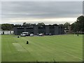
School sports fields, Framwellgate School
View to the rear of Framwellgate school across the playing fields.
Image: © David Robinson
Taken: 23 Aug 2018
0.24 miles
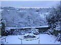
9
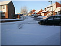
Bishops Way, Pity Me. Dec 05
Snow................December 27th 2005
Image: © Eric Haswell
Taken: 29 Dec 2005
0.24 miles