IMAGES TAKEN NEAR TO
Dryburn Road, DURHAM, DH1 5AJ
Introduction
This page details the photographs taken nearby to Dryburn Road, DH1 5AJ by members of the Geograph project.
The Geograph project started in 2005 with the aim of publishing, organising and preserving representative images for every square kilometre of Great Britain, Ireland and the Isle of Man.

There are currently over 7.5m images from over14,400 individuals and you can help contribute to the project by visiting https://www.geograph.org.uk
Image Map
Images are licensed for reuse under creativecommons.org/licenses/by-sa/2.0
Notes
- Clicking on the map will re-center to the selected point.
- The higher the marker number, the further away the image location is from the centre of the postcode.
Image Listing (17 Images Found)
Images are licensed for reuse under creativecommons.org/licenses/by-sa/2.0
Image
Details
Distance
1
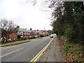
Dryburn Road, Durham
This road leads into the suburbs on the NW side of Durham City from Sacriston.
Image: © Robert Graham
Taken: 15 Apr 2013
0.01 miles
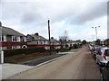
2
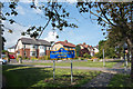
Semi-detached houses in Framwellgate Moor
Framwellgate Moor is an area of Durham city, north of the centre. The houses are on Durham Moor Crescent. The blue and yellow sign is in a style in use in County Durham for some time.
Image: © Trevor Littlewood
Taken: 11 Sep 2015
0.07 miles
3
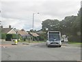
Weardale Travel bus turning out of Dryburn Road Durham towards the A167
Image: © Peter Robinson
Taken: 18 Sep 2013
0.09 miles
4
Entrance to University Hospital Durham from Dryburn Road
Image: © Peter Robinson
Taken: 18 Sep 2013
0.10 miles
5
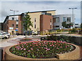
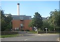
University Hospital of North Durham
A new hospital on the north-western outskirts of Durham city; seen from the car park.
Image: © Trevor Littlewood
Taken: 5 Jul 2010
0.11 miles
6
Dryburn Park, Durham
A street on the NW side of Durham, next to Framwellgate Moor. Large semis, possibly late thirties, but might be postwar.
Image: © Robert Graham
Taken: 15 Apr 2013
0.12 miles
7
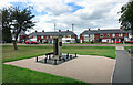
War Memorial on the Green
In a small triangular park where Front Street meets Finchale Road.
Image: © Des Blenkinsopp
Taken: 26 Aug 2022
0.13 miles
8
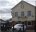
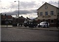
The Salutation Inn, Framwellgate Moor
Near New College, Durham.
Image: © Stanley Howe
Taken: 21 Sep 2013
0.16 miles
9
Hand shakes at 'The Sally'
The Salutation pub at Framwellgate Moor.
Image: © Stanley Howe
Taken: 21 Sep 2013
0.16 miles
10
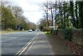
View down Dryburn Road, Durham
This is the B6532, coming into the city from the NW.
Image: © Robert Graham
Taken: 25 Mar 2021
0.17 miles