IMAGES TAKEN NEAR TO
Crossgate Moor, DURHAM, DH1 4TG
Introduction
This page details the photographs taken nearby to DH1 4TG by members of the Geograph project.
The Geograph project started in 2005 with the aim of publishing, organising and preserving representative images for every square kilometre of Great Britain, Ireland and the Isle of Man.

There are currently over 7.5m images from over14,400 individuals and you can help contribute to the project by visiting https://www.geograph.org.uk
Image Map
Images are licensed for reuse under creativecommons.org/licenses/by-sa/2.0
Notes
- Clicking on the map will re-center to the selected point.
- The higher the marker number, the further away the image location is from the centre of the postcode.
Image Listing (13 Images Found)
Images are licensed for reuse under creativecommons.org/licenses/by-sa/2.0
Image
Details
Distance
2
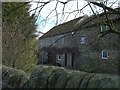
Baxter Wood Cottages
The Cottages are part of the farm buildings.
Image: © Gordon Griffiths
Taken: 14 Mar 2008
0.04 miles
4
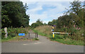
Gate on the Railway Path
At Baxter Wood Farm where a bridleway crosses the Lanchester Valley Railway Path.
Image: © Des Blenkinsopp
Taken: 23 Aug 2022
0.07 miles

6

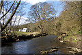
River Browney near Baxter Wood
A tributary of the River Wear.
Image: © Oliver Dixon
Taken: 17 Feb 2007
0.11 miles
7
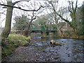
Browney Bridge
Bridge at Baxter Wood crossing the River Browney
Image: © Malcolm Coils
Taken: 26 Dec 2014
0.13 miles
8
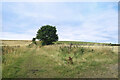
Bridleway at Baxter Wood
A bridleway heads up out of the valley into farmland.
Image: © Des Blenkinsopp
Taken: 23 Aug 2022
0.14 miles
9
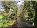
River Browney
River Browney in spring.
Image: © David Robinson
Taken: 25 Apr 2018
0.15 miles
10
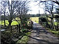
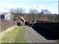
Lane approaching Baxter Wood Farm
A favourite place for playing Pooh Sticks!
Image: © Roger Smith
Taken: 2 Mar 2008
0.15 miles