IMAGES TAKEN NEAR TO
Valeside, DURHAM, DH1 4RF
Introduction
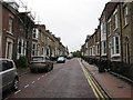
This page details the photographs taken nearby to Valeside, DH1 4RF by members of the Geograph project.
The Geograph project started in 2005 with the aim of publishing, organising and preserving representative images for every square kilometre of Great Britain, Ireland and the Isle of Man.

There are currently over 7.5m images from over14,400 individuals and you can help contribute to the project by visiting https://www.geograph.org.uk
Image Map
Images are licensed for reuse under creativecommons.org/licenses/by-sa/2.0
Notes
- Clicking on the map will re-center to the selected point.
- The higher the marker number, the further away the image location is from the centre of the postcode.
Image Listing (141 Images Found)
Images are licensed for reuse under creativecommons.org/licenses/by-sa/2.0
Image
Details
Distance
1
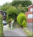
Footpath between the houses
Part of the Northern Saints Trails.
http://northernsaints.com/
Image: © Russel Wills
Taken: 4 Oct 2022
0.01 miles
2
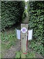
Northern Saints Trails waymark
This is the reverse view of https://www.geograph.org.uk/photo/7308497
The reverse side requests dog walkers to clear up after their dogs.
Image: © Russel Wills
Taken: 4 Oct 2022
0.02 miles
3
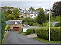
Valeside - a leafy Durham suburb
Close to the city centre.
Image: © Russel Wills
Taken: 4 Oct 2022
0.02 miles
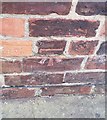
4
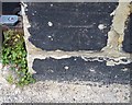
Ordnance Survey Cut Mark
This OS cut mark can be found on No40 Albert Street. It marks a point 86.237m above mean sea level.
Image: © Adrian Dust
Taken: 14 Sep 2018
0.07 miles
6
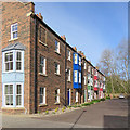
Durham: The Bowers, Waddington Street
A recent development of houses in the local vernacular style, built on the site of a bus depot.
Image: © John Sutton
Taken: 15 Apr 2017
0.10 miles
8
Ordnance Survey Cut Mark
This OS cut mark can be found on No5 West Terrace. It marks a point 71.543m above mean sea level.
Image: © Adrian Dust
Taken: 14 Sep 2018
0.11 miles
9
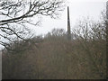
Obelisk in North Road Durham City
Seen from Wharton Park built in 1840 a marker point for Durham University's Observatory which lies a mile to the south near Durham School.
Image: © Peter Robinson
Taken: 27 Feb 2011
0.13 miles
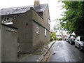
10
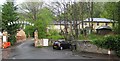
Durham: Kings Lodge Hotel
On the edge of woodland at the end of Waddington Street.
Image: © John Sutton
Taken: 11 May 2015
0.13 miles