IMAGES TAKEN NEAR TO
Kells Buildings, DURHAM, DH1 4JL
Introduction
This page details the photographs taken nearby to Kells Buildings, DH1 4JL by members of the Geograph project.
The Geograph project started in 2005 with the aim of publishing, organising and preserving representative images for every square kilometre of Great Britain, Ireland and the Isle of Man.

There are currently over 7.5m images from over14,400 individuals and you can help contribute to the project by visiting https://www.geograph.org.uk
Image Map
Images are licensed for reuse under creativecommons.org/licenses/by-sa/2.0
Notes
- Clicking on the map will re-center to the selected point.
- The higher the marker number, the further away the image location is from the centre of the postcode.
Image Listing (21 Images Found)
Images are licensed for reuse under creativecommons.org/licenses/by-sa/2.0
Image
Details
Distance
1
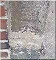
Ordnance Survey Cut Mark
This OS cut mark can be found on the gatepost of No4 Kells Terrace. It marks a point 78.242m above mean sea level.
Image: © Adrian Dust
Taken: 14 Sep 2018
0.01 miles
2
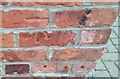
Ordnance Survey Cut Mark
This OS cut mark can be found on Ashville, Nevilles Cross Bank. It marks a point 88.084m above mean sea level.
Image: © Adrian Dust
Taken: 14 Sep 2018
0.08 miles
3
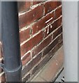
Ordnance Survey Cut Mark
This OS cut mark can be found on No9 Darlington Road. It marks a point 95.710m above mean sea level.
Image: © Adrian Dust
Taken: 14 Sep 2018
0.14 miles
4
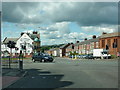
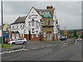
Junction of the A690 and A167
With Michelangelo's Bar and Restaurant to the left of the photo
Image: © Alexander P Kapp
Taken: 24 Jun 2011
0.14 miles
5
Michelangelo, Neville's Cross
The Michelangelo bar and ristorante at the Nevill'e Cross junction on the A167, Darlington Road.
Image: © David Dixon
Taken: 22 Jun 2011
0.14 miles
6
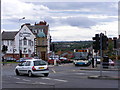
Neville's Cross Junction
The A167 at Neville's Cross Durham.
Image: © Gordon Griffiths
Taken: 28 Jun 2008
0.15 miles
8
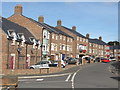
Dalton Crescent, Neville's Cross, Durham
A crescent of modern town houses, just off the former A1.
Image: © David Hawgood
Taken: 11 Sep 2016
0.19 miles
9

Ordnance Survey Cut Mark
This OS cut mark can be found on the wall NW end of George Street. It marks a point 100.267m above mean sea level.
Image: © Adrian Dust
Taken: 14 Sep 2018
0.20 miles
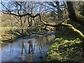
10
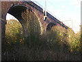
Relly Mill Viaduct
Where the East Coast main line crosses the deep valley of the River Browney, just to the south-west of Durham city. The viaduct stands over the original Relly Mill. Underneath the far arch of the viaduct is the remains of the abutment of the original wooden viaduct of the Bishop Auckland Branch (additional information supplied by Craig Oliphant).
Image: © Oliver Dixon
Taken: 18 Feb 2006
0.21 miles