IMAGES TAKEN NEAR TO
Blaidwood Drive, DURHAM, DH1 3TD
Introduction
This page details the photographs taken nearby to Blaidwood Drive, DH1 3TD by members of the Geograph project.
The Geograph project started in 2005 with the aim of publishing, organising and preserving representative images for every square kilometre of Great Britain, Ireland and the Isle of Man.

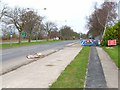
There are currently over 7.5m images from over14,400 individuals and you can help contribute to the project by visiting https://www.geograph.org.uk
Image Map (Loading...)


Getting Data...Please wait
Leaflet Map data © OpenStreetMap
Images are licensed for reuse under creativecommons.org/licenses/by-sa/2.0
Notes
- Clicking on the map will re-center to the selected point.
- The higher the marker number, the further away the image location is from the centre of the postcode.
Image Listing (13 Images Found)
Images are licensed for reuse under creativecommons.org/licenses/by-sa/2.0
Image
Details
Distance
1
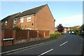
Roundhaven from the A177
A street off South Road in Durham.
Image: © DS Pugh
Taken: 25 Aug 2023
0.10 miles
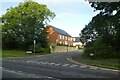
2
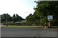
Entrance to Durham High School for Girls
The school entrance along the A177 South Road.
Image: © DS Pugh
Taken: 25 Aug 2023
0.11 miles
3
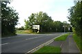
Entrance to Low Burnhall
An entrance to the Woodland Trust car park off the A177 South Road near Cock o' the North roundabout.
Image: © DS Pugh
Taken: 25 Aug 2023
0.11 miles
4
Where the Cock o' the North once stood
Until recently a roadhouse named Cock o'the North stood here on the A167 at the southern approaches to Durham. Now a building site for more "executive homese"
Image: © Oliver Dixon
Taken: 20 Apr 2006
0.12 miles
5
A167 on the southern approaches to Durham
This section of road was at one time the A1 (Great North Road). Hence the dual carriageway and cycle tracks alongside. Despite the construction of the A1(M) on the east side of the city, this road is still extremely busy
Image: © Oliver Dixon
Taken: 20 Apr 2006
0.12 miles
6
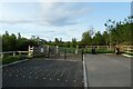
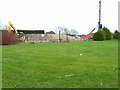
Car park at Low Burnhall
Low Burnhall is a Woodland Trust site to the south of Durham.
Image: © DS Pugh
Taken: 25 Aug 2023
0.16 miles
7
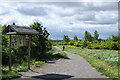
Dog walking from Low Burnhall
A lone walker with his dog heading away from the Low Burnhall car park at the northern end of the Woodland Trust's property.
Image: © Trevor Littlewood
Taken: 9 Jun 2024
0.16 miles
8
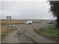
Entrance to car park for Low Burnhall Woodland Trust land
Image: © Peter Robinson
Taken: 1 Mar 2013
0.17 miles
9
Richardby Crescent
Looking across South Road to Richardby Crescent.
Image: © DS Pugh
Taken: 25 Aug 2023
0.20 miles
10
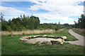
Stone Circle, Low Burnhall Wood
There are a lot of tracks and trails around Low Burnhall Wood with various features at intervals. Some stone, like this, some wickerwork, and some old industrial relics.
Image: © Des Blenkinsopp
Taken: 24 Aug 2022
0.21 miles