IMAGES TAKEN NEAR TO
DURHAM, DH1 3SD
Introduction
This page details the photographs taken nearby to DH1 3SD by members of the Geograph project.
The Geograph project started in 2005 with the aim of publishing, organising and preserving representative images for every square kilometre of Great Britain, Ireland and the Isle of Man.

There are currently over 7.5m images from over14,400 individuals and you can help contribute to the project by visiting https://www.geograph.org.uk
Image Map
Images are licensed for reuse under creativecommons.org/licenses/by-sa/2.0
Notes
- Clicking on the map will re-center to the selected point.
- The higher the marker number, the further away the image location is from the centre of the postcode.
Image Listing (23 Images Found)
Images are licensed for reuse under creativecommons.org/licenses/by-sa/2.0
Image
Details
Distance
1
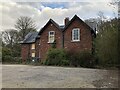
Mountjoy House
Former farmhouse and associated buildings on Mountjoy Hill, to the rear of the University Science Site. The property has spectacular uninterrupted views across to the cathedral, and would surely sell for a substantial sum to a developer. However, I can't find any information as to ownership or how long the house has been derelict (as of August 2021 when posted).
Image: © David Robinson
Taken: 8 Apr 2021
0.01 miles
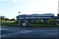
2
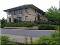
John Snow House, NHS Headquarters
Named after John Snow, an eminent Victorian physician 1813 - 1858. He played a major part in promoting early anaesthesia and was also renowned for work regarding the spread of cholera.
Image: © Roger Smith
Taken: 17 Jun 2007
0.03 miles
3
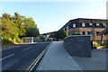
Campus road
Passing the Chemistry department.
Image: © DS Pugh
Taken: 28 Aug 2014
0.11 miles
4
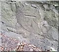
Ordnance Survey Cut Mark
This OS cut mark can be found on the retaining wall north side of the Road. It marks a point 45.494m above mean sea level.
Image: © Adrian Dust
Taken: 14 Sep 2018
0.16 miles
6
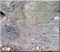
Ordnance Survey Cut Mark
This OS cut mark can be found on the retaining wall north side of the road. It marks a point 56.428m above mean sea level.
Image: © Adrian Dust
Taken: 14 Sep 2018
0.17 miles
7
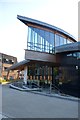
Durham Law School
Amongst a cluster of Durham University buildings here.
Image: © DS Pugh
Taken: 28 Aug 2014
0.17 miles
9
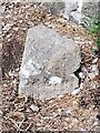
Old Boundary Marker on the A177 Stockton Road, Durham
Municipal Boundary Marker against a stone wall on the northeast side of the A177 Stockton Road just southeast of its junction with Whinney Hill. City of Durham parish. Inscribed D.U. (/ S.A) on its left face and D & C S (/ H B) on its right face. The stone marked the road maintenance responsibility boundary between the Durham Urban Sanitary Authority and the Durham and Chester-le-Street Highway Board, although the city boundary ran up the centre of the road here.
Milestone Society National ID: DU_DUR09pb
Image: © Mike Rayner
Taken: 24 Aug 2022
0.19 miles