IMAGES TAKEN NEAR TO
Old Elvet, DURHAM, DH1 3BN
Introduction
This page details the photographs taken nearby to Old Elvet, DH1 3BN by members of the Geograph project.
The Geograph project started in 2005 with the aim of publishing, organising and preserving representative images for every square kilometre of Great Britain, Ireland and the Isle of Man.

There are currently over 7.5m images from over14,400 individuals and you can help contribute to the project by visiting https://www.geograph.org.uk
Image Map (Loading...)


Getting Data...Please wait
Leaflet Map data © OpenStreetMap
Images are licensed for reuse under creativecommons.org/licenses/by-sa/2.0
Notes
- Clicking on the map will re-center to the selected point.
- The higher the marker number, the further away the image location is from the centre of the postcode.
Image Listing (130 Images Found)
Images are licensed for reuse under creativecommons.org/licenses/by-sa/2.0
Image
Details
Distance
1
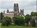
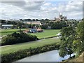
Durham Race Course
View to Cathedral above University Cricket Ground
Image: © Malcolm Coils
Taken: 19 Jul 2019
0.02 miles
2
Durham Elvet railway station (site), County Durham
Opened in 1893 by the North Eastern Railway as the terminus of a short branch line from Sherburn House, this station closed to passengers in 1931 and completely in 1954. The station was demolished in 1964 and new buildings now occupy the site.
View west along the former island platform towards the buffers. The building to the left covers the site of the platform, the one in the distance is on the site of the terminus building.
For more information, see http://www.disused-stations.org.uk/d/durham_elvet/index.shtml
Image: © Nigel Thompson
Taken: 10 Jan 2017
0.04 miles
3
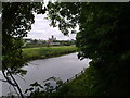
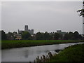
View of the city from Pelaw Wood
Looking across the river and the racecourse to a view of the city and the Cathedral.
Image: © Robert Graham
Taken: 12 Jul 2011
0.04 miles
5
Durham Elvet railway station (site), County Durham
Opened in 1893 by the North Eastern Railway as the terminus of a short branch line from Sherburn House, this station closed to passengers in 1931 and completely in 1954. The station was demolished in 1964 and a new building now occupies the site.
View east towards the former forecourt. The single island platform stretched away behind the station building. No trace of either remains.
For more information, see http://www.disused-stations.org.uk/d/durham_elvet/index.shtml
Image: © Nigel Thompson
Taken: 10 Jan 2017
0.04 miles
7
Pavilion at the Racecourse, Durham
The Racecourse is a sports ground belonging to Durham University next to the River Wear, used as a sports ground since at least 1733. Besides its squash, tennis and fives courts, cricket, rugby, hockey and football pitches and rowing houses, it hosts two annual events: the Durham Regatta and Durham Miners' Gala.
Image: © Paul Harrop
Taken: 10 Nov 2013
0.05 miles
8
Durham University Cricket Grounds
View to the University cricket grounds across the Wear with the cathedral prominent in the background. This view was opened up following a landslip on the steep riverside bank in 2013, prior to then this area was mature woodland. The footpaths through the landslip area were closed for four years while the land was stabilised. The footpaths were re-opened in 2017.
Image: © David Robinson
Taken: 6 Sep 2018
0.06 miles
9
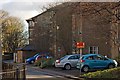
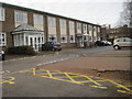
Parson's Green, Durham
The buildings are Refounders and Brooks Houses, Durham University halls of residence belonging to St Cuthbert's College. This was originally the site of Durham's first passenger railway station, Durham Elvet, which opened in 1893 and closed in 1954.
Image: © Paul Harrop
Taken: 16 Feb 2014
0.06 miles