IMAGES TAKEN NEAR TO
Mount Joy Crescent, DURHAM, DH1 3BA
Introduction
This page details the photographs taken nearby to Mount Joy Crescent, DH1 3BA by members of the Geograph project.
The Geograph project started in 2005 with the aim of publishing, organising and preserving representative images for every square kilometre of Great Britain, Ireland and the Isle of Man.

There are currently over 7.5m images from over14,400 individuals and you can help contribute to the project by visiting https://www.geograph.org.uk
Image Map (Loading...)


Getting Data...Please wait
Leaflet Map data © OpenStreetMap
Images are licensed for reuse under creativecommons.org/licenses/by-sa/2.0
Notes
- Clicking on the map will re-center to the selected point.
- The higher the marker number, the further away the image location is from the centre of the postcode.
Image Listing (64 Images Found)
Images are licensed for reuse under creativecommons.org/licenses/by-sa/2.0
Image
Details
Distance
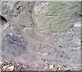
1
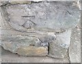
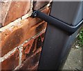
Ordnance Survey Cut Mark
This OS cut mark can be found on the wall of No1 Mountjoy Crescent. It marks a point 55.559m above mean sea level.
Image: © Adrian Dust
Taken: 14 Sep 2018
0.03 miles
2
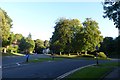
Stockton Road Roundabout
A177 meets Hallgarth Street.
Image: © DS Pugh
Taken: 28 Aug 2014
0.03 miles
3
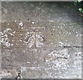
Ordnance Survey Cut Mark
This OS cut mark can be found on the wall north side of Stockton Road. It marks a point 55.288m above mean sea level.
Image: © Adrian Dust
Taken: 14 Sep 2018
0.06 miles
4
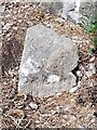
Old Boundary Marker on the A177 Stockton Road, Durham
Municipal Boundary Marker against a stone wall on the northeast side of the A177 Stockton Road just southeast of its junction with Whinney Hill. City of Durham parish. Inscribed D.U. (/ S.A) on its left face and D & C S (/ H B) on its right face. The stone marked the road maintenance responsibility boundary between the Durham Urban Sanitary Authority and the Durham and Chester-le-Street Highway Board, although the city boundary ran up the centre of the road here.
Milestone Society National ID: DU_DUR09pb
Image: © Mike Rayner
Taken: 24 Aug 2022
0.07 miles
6
Ordnance Survey Cut Mark
This OS cut mark can be found on No37 Whinney Hill. It marks a point 63.085m above mean sea level.
Image: © Adrian Dust
Taken: 14 Sep 2018
0.07 miles
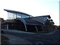
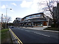
8
New Law School building, Durham University
New development on the edge of the University's Science Site, Stockton Road.
Image: © David Martin
Taken: 30 Sep 2012
0.08 miles
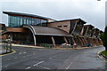
9
Palatine Centre, Durham University, Stockton Road
Image: © Les Hull
Taken: 16 Feb 2014
0.08 miles
10
Ordnance Survey Cut Mark
This OS cut mark can be found on the retaining wall north side of the road. It marks a point 56.428m above mean sea level.
Image: © Adrian Dust
Taken: 14 Sep 2018
0.09 miles