IMAGES TAKEN NEAR TO
Shincliffe, DURHAM, DH1 2TJ
Introduction
This page details the photographs taken nearby to DH1 2TJ by members of the Geograph project.
The Geograph project started in 2005 with the aim of publishing, organising and preserving representative images for every square kilometre of Great Britain, Ireland and the Isle of Man.

There are currently over 7.5m images from over14,400 individuals and you can help contribute to the project by visiting https://www.geograph.org.uk
Image Map
Images are licensed for reuse under creativecommons.org/licenses/by-sa/2.0
Notes
- Clicking on the map will re-center to the selected point.
- The higher the marker number, the further away the image location is from the centre of the postcode.
Image Listing (17 Images Found)
Images are licensed for reuse under creativecommons.org/licenses/by-sa/2.0
Image
Details
Distance
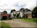
1
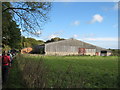
Farm buildings at High Butterby Farm
Image: © Peter Robinson
Taken: 16 Oct 2011
0.01 miles
2
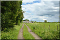
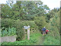
Weardale Way approaching High Butterby Farm
The farm road is heading north-east towards the farm, a barn of which can be seen. The trees to the left are of Butterby Wood which is on a slope dropping away sharply northwards towards the River Wear.
Image: © Trevor Littlewood
Taken: 8 Jun 2014
0.01 miles
3
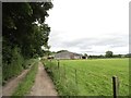
Approaching High Butterby
Looking east along the track leading from Croxdale Hall. Butterby Wood to the left.
Image: © Robert Graham
Taken: 24 Jul 2012
0.01 miles
4
Weardale Way approaching High Butterby Farm
Image: © Chris Heaton
Taken: 16 May 2023
0.02 miles
5
Footpath to Shincliffe Hall and beyond through The Sliddings woodland
Image: © Peter Robinson
Taken: 16 Oct 2011
0.03 miles
6
High Butterby Farm
The name 'Butterby' is linked to Low Butterby Farm on the bank of the Wear, below here. Its name is believed to have been given by the Normans, 'beau trouvé' = well-found, and later assimilated to a more Scandinavian '-by' type of place-name https://altogetherarchaeology.org/Place%20Names/PLACE-NAMES%20OF%20NORTHUMBERLAND%20AND%20DURHAM.pdf .
Image: © Tim Heaton
Taken: 16 May 2023
0.03 miles
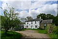
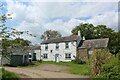
7
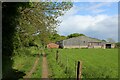
High Butterby Farmhouse
Big old farmhouse on the Croxdale Estate. Presumably 19th century.
Image: © Robert Graham
Taken: 24 Jul 2012
0.04 miles
8
High Butterby Farm
Temporary dovecote enclosed by chicken wire on the left of the photo
Image: © Oliver Dixon
Taken: 20 Apr 2006
0.04 miles
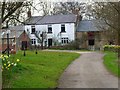
10
High Butterby Farm
The Weardale Way passes in front of the farmhouse, before diving down into deep woodland back towards the river's edge
Image: © Chris Heaton
Taken: 16 May 2023
0.04 miles