IMAGES TAKEN NEAR TO
Shincliffe, DURHAM, DH1 2TD
Introduction
This page details the photographs taken nearby to DH1 2TD by members of the Geograph project.
The Geograph project started in 2005 with the aim of publishing, organising and preserving representative images for every square kilometre of Great Britain, Ireland and the Isle of Man.

There are currently over 7.5m images from over14,400 individuals and you can help contribute to the project by visiting https://www.geograph.org.uk
Image Map
Images are licensed for reuse under creativecommons.org/licenses/by-sa/2.0
Notes
- Clicking on the map will re-center to the selected point.
- The higher the marker number, the further away the image location is from the centre of the postcode.
Image Listing (9 Images Found)
Images are licensed for reuse under creativecommons.org/licenses/by-sa/2.0
Image
Details
Distance
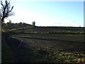
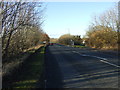
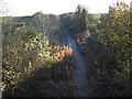
2
Strawberry Lane
Strawberry Lane is an old bridleway near High Shincliffe.
Image: © David Robinson
Taken: 15 Mar 2021
0.15 miles
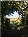
3
Strawberry Lane
A Public Bridleway In Shincliffe Estate, County Durham
Image: © Peter Robinson
Taken: 5 Jul 2009
0.18 miles
4
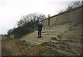
Remains of Shincliffe Racecourse Grandstand in 1992
The course was last used pre WW1
Image: © Peter Robinson
Taken: Unknown
0.18 miles
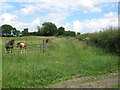
6
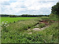
Former racecourse grandstand
Adjacent to Strawberry Lane the remains with the course area beyond. Shincliffe Racecourse opened in 1895 and was closed by the start of the First World War.
Image: © Peter Robinson
Taken: 5 Jul 2009
0.22 miles
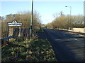
7
Shincliffe railway station (site), County Durham
Opened in 1844 by the Newcastle & Darlington Junction Railway, later to be part of the North Eastern Railway, on the line via Ferryhill and Leamside, this station closed to passengers in 1941 and completely in 1963.
View south towards Ferryhill and Darlington. The track was lifted in 2012. The station building was still extant when this image was taken, but was hidden from view by the encroaching vegetation.
For more information, see http://disused-stations.org.uk/s/shincliffe/index.shtml
Image: © Nigel Thompson
Taken: 29 May 2021
0.24 miles
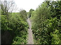
9
Disused railway heading south
This view shows the site of the former Shincliffe station, closed to passengers in 1941. Further information on the station, including photographs before and after closure, and on the history of the railway can be found at http://www.disused-stations.org.uk/s/shincliffe/index.shtml
Image: © JThomas
Taken: 17 Nov 2012
0.24 miles