IMAGES TAKEN NEAR TO
Beal Walk, DURHAM, DH1 2PL
Introduction
This page details the photographs taken nearby to Beal Walk, DH1 2PL by members of the Geograph project.
The Geograph project started in 2005 with the aim of publishing, organising and preserving representative images for every square kilometre of Great Britain, Ireland and the Isle of Man.

There are currently over 7.5m images from over14,400 individuals and you can help contribute to the project by visiting https://www.geograph.org.uk
Image Map
Images are licensed for reuse under creativecommons.org/licenses/by-sa/2.0
Notes
- Clicking on the map will re-center to the selected point.
- The higher the marker number, the further away the image location is from the centre of the postcode.
Image Listing (12 Images Found)
Images are licensed for reuse under creativecommons.org/licenses/by-sa/2.0
Image
Details
Distance
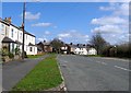
2

High Street, High Shincliffe, with Avenue St in the distance
Image: © Roger Smith
Taken: 16 Apr 2008
0.12 miles
3
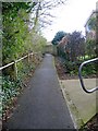
Footpath connecting Low to High Shincliffe
Image: © Roger Smith
Taken: 16 Apr 2008
0.14 miles
4
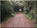
Tree lined lane south of Manor Farm
Image: © GRAEME and LESLEY CRANSTON
Taken: 14 Sep 2006
0.17 miles
10
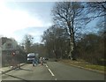
A177 Road Works
The view at Shincliffe, Durham.
Image: © Gordon Griffiths
Taken: 10 Mar 2014
0.23 miles