IMAGES TAKEN NEAR TO
Robson Terrace, DURHAM, DH1 2NL
Introduction
This page details the photographs taken nearby to Robson Terrace, DH1 2NL by members of the Geograph project.
The Geograph project started in 2005 with the aim of publishing, organising and preserving representative images for every square kilometre of Great Britain, Ireland and the Isle of Man.

There are currently over 7.5m images from over14,400 individuals and you can help contribute to the project by visiting https://www.geograph.org.uk
Image Map
Images are licensed for reuse under creativecommons.org/licenses/by-sa/2.0
Notes
- Clicking on the map will re-center to the selected point.
- The higher the marker number, the further away the image location is from the centre of the postcode.
Image Listing (46 Images Found)
Images are licensed for reuse under creativecommons.org/licenses/by-sa/2.0
Image
Details
Distance
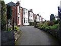
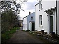
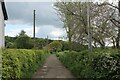
4
Weardale Way heading into the Village of Shincliffe from the South
Image: © Chris Heaton
Taken: 16 May 2023
0.06 miles
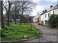
6
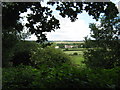
Shincliffe Village County Durham
The south east corner of the village viewed from Shincliffe Wood
Image: © Peter Robinson
Taken: 5 Jul 2009
0.07 miles
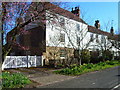
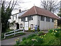
8
Springtime in High Street, Low Shincliffe
Image: © Oliver Dixon
Taken: 10 Apr 2006
0.09 miles
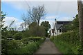
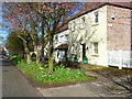
10
Hall Lane heading South
Narrow lane heading south towards Shincliffe Wood - adopted by the Weardale Way long distance footpath
Image: © Chris Heaton
Taken: 16 May 2023
0.10 miles