IMAGES TAKEN NEAR TO
St. Marys Close, DURHAM, DH1 2ND
Introduction
This page details the photographs taken nearby to St. Marys Close, DH1 2ND by members of the Geograph project.
The Geograph project started in 2005 with the aim of publishing, organising and preserving representative images for every square kilometre of Great Britain, Ireland and the Isle of Man.

There are currently over 7.5m images from over14,400 individuals and you can help contribute to the project by visiting https://www.geograph.org.uk
Image Map
Images are licensed for reuse under creativecommons.org/licenses/by-sa/2.0
Notes
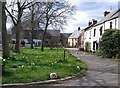
- Clicking on the map will re-center to the selected point.
- The higher the marker number, the further away the image location is from the centre of the postcode.
Image Listing (52 Images Found)
Images are licensed for reuse under creativecommons.org/licenses/by-sa/2.0
Image
Details
Distance
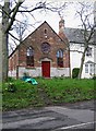
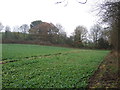
3
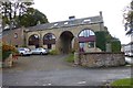
Shincliffe Town railway station (site), County Durham
Opened as "Shincliffe" in 1839 by the Durham and Sunderland Railway, later part of the North Eastern Railway, this was the western passenger terminus of the line - about 3 miles from Durham. "Town" was added to the name in 1861 and the station closed in 1893 when the line was diverted from Sherburn House to Durham (Elvet) station.
View east at the former forecourt. It is now a private residence.
Image: © Nigel Thompson
Taken: 29 May 2021
0.07 miles
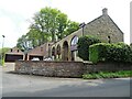
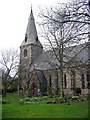
5

Ordnance Survey Cut Mark
This OS cut mark can be found on the west face of St Mary's Church. It marks a point 50.280m above mean sea level.
Image: © Adrian Dust
Taken: 19 Sep 2018
0.07 miles
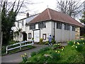
9
The Mews
On Low Road approaching Shincliffe.
Image: © Russel Wills
Taken: 23 Oct 2016
0.08 miles