IMAGES TAKEN NEAR TO
Chapel Heights, DURHAM, DH1 1SJ
Introduction
This page details the photographs taken nearby to Chapel Heights, DH1 1SJ by members of the Geograph project.
The Geograph project started in 2005 with the aim of publishing, organising and preserving representative images for every square kilometre of Great Britain, Ireland and the Isle of Man.

There are currently over 7.5m images from over14,400 individuals and you can help contribute to the project by visiting https://www.geograph.org.uk
Image Map
Images are licensed for reuse under creativecommons.org/licenses/by-sa/2.0
Notes
- Clicking on the map will re-center to the selected point.
- The higher the marker number, the further away the image location is from the centre of the postcode.
Image Listing (89 Images Found)
Images are licensed for reuse under creativecommons.org/licenses/by-sa/2.0
Image
Details
Distance
1
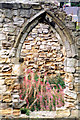
Chapel of St Mary Magdalene, Carville Link Road, Durham
14th century east window of the 15th century hospital chapel founded in the 13th century. Grade I Listed and Scheduled Ancient Monument.
Image: © Jo and Steve Turner
Taken: 30 Aug 1999
0.02 miles
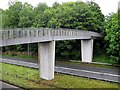
4
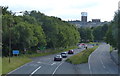
Durham Footbridge View
The A690 view towards the Durham Cathedral and Castle.
Image: © Gordon Griffiths
Taken: 7 Mar 2014
0.05 miles
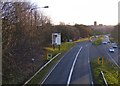
5
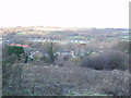
Houses in Durham
These houses are at the beginning of the promontory of land which ends with the rock on which Durham Cathedral is built within a loop of the river Wear. Beyond the houses, and across the river, is a sewage works and further away Framwellgate Moor. The rough ground in the foreground was once alongside a railway, now replaced by the A690 road.
Image: © David Hawgood
Taken: 23 Dec 2005
0.06 miles
7
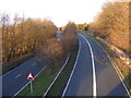
The view leaving Durham
The A690 view from the footbridge.
Image: © Gordon Griffiths
Taken: 7 Mar 2014
0.06 miles
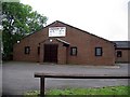
9
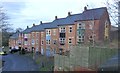
Terraced town houses on Ashwood
They back onto the Kingdom Hall of Jehovah's Witnesses.
Image: © Russel Wills
Taken: 25 Dec 2018
0.07 miles
10
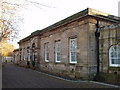
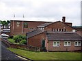
Former Gilesgate Railway Station, Durham (now a hotel)
Gilesgate Station was built in the 1840s and was then the main Durham station for trains to London. See www.thisisthenortheast.co.uk http://www.thisisthenortheast.co.uk/the_north_east/history/echomemories/durham/203/090503.html where David Simpson (author of "North-East England: places, history, people and legends") tells us:
"It was the railway entrepreneur George Hudson who built the main line northwards from York from around 1841. Near Durham, his line was what we know today as the Leamside line, and lies to the east of the city. In his time, Hudson's line was called the Newcastle and Durham Junction Railway and became part of the North Eastern Railway in the early 1850s." and "Shincliffe Bank Top and Gilesgate stations were both built in stone by the architect JT Andrews, from York, and both are rather attractive buildings that look more Georgian than Victorian."
The building is now a Travelodge hotel, where the photographer stayed when he took the photo.
Image: © David Hawgood
Taken: 23 Dec 2005
0.09 miles