IMAGES TAKEN NEAR TO
Dunragit, STRANRAER, DG9 8PJ
Introduction
This page details the photographs taken nearby to DG9 8PJ by members of the Geograph project.
The Geograph project started in 2005 with the aim of publishing, organising and preserving representative images for every square kilometre of Great Britain, Ireland and the Isle of Man.

There are currently over 7.5m images from over14,400 individuals and you can help contribute to the project by visiting https://www.geograph.org.uk
Image Map
Images are licensed for reuse under creativecommons.org/licenses/by-sa/2.0
Notes
- Clicking on the map will re-center to the selected point.
- The higher the marker number, the further away the image location is from the centre of the postcode.
Image Listing (52 Images Found)
Images are licensed for reuse under creativecommons.org/licenses/by-sa/2.0
Image
Details
Distance
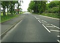
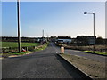
1
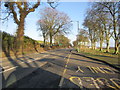
Dunragit Road
The A75 going in the direction of Glenluce.
Image: © Billy McCrorie
Taken: 5 Mar 2012
0.04 miles
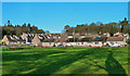
2
Dunragit
View along the A75 as it runs through the village.
Image: © Andy Farrington
Taken: 18 Aug 2010
0.04 miles
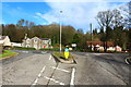
6
Dunragit Village
The park lies next to the former A75, much quieter nowadays after the construction of the Dunragit by-pass.
Image: © Mary and Angus Hogg
Taken: 22 Nov 2015
0.06 miles
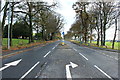
8
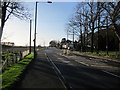
Dunragit Road
In the direction of Stranraer.
Image: © Billy McCrorie
Taken: 5 Mar 2012
0.07 miles
9
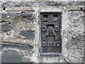
Ordnance Survey Flush Bracket G4190
This can be found on the wall of a house at Dunragit.
For more detail see : http://www.bench-marks.org.uk/bm17033
Image: © Peter Wood
Taken: 21 Sep 2013
0.07 miles
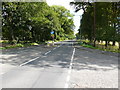
10
From the A75 to the B7084
Side road with level crossing.
Image: © Billy McCrorie
Taken: 5 Mar 2012
0.07 miles