IMAGES TAKEN NEAR TO
Wigtown, NEWTON STEWART, DG8 9TE
Introduction
This page details the photographs taken nearby to DG8 9TE by members of the Geograph project.
The Geograph project started in 2005 with the aim of publishing, organising and preserving representative images for every square kilometre of Great Britain, Ireland and the Isle of Man.

There are currently over 7.5m images from over14,400 individuals and you can help contribute to the project by visiting https://www.geograph.org.uk
Image Map (Loading...)


Getting Data...Please wait
Leaflet Map data © OpenStreetMap
Images are licensed for reuse under creativecommons.org/licenses/by-sa/2.0
Notes
- Clicking on the map will re-center to the selected point.
- The higher the marker number, the further away the image location is from the centre of the postcode.
Image Listing (6 Images Found)
Images are licensed for reuse under creativecommons.org/licenses/by-sa/2.0
Image
Details
Distance
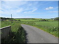
1
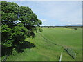
Northwest from Kirkland Hill, Wigtown
Farmland around the A714 to Newton Stewart.
Image: © Jim Barton
Taken: 4 Sep 2024
0.10 miles
2
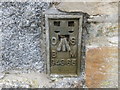
Ordnance Survey Flush Bracket G4365
This can be found on the wall of a former barn at Culquirk Farm.
For more detail see : http://www.bench-marks.org.uk/bm11442
Image: © Peter Wood
Taken: 24 Sep 2013
0.17 miles
3
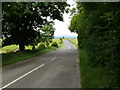
Culquhirk
View along the B7005 to these cottage left of picture on the horizon
Image: © Andy Farrington
Taken: 12 Jul 2010
0.20 miles
4
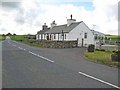
Culquhirk
A couple of cottages on the B7005 which is effectively a by-pass for Wigtown. Located at the junction with the main A714 which goes into Wigtown before continuing on to Whithorn.
Image: © Oliver Dixon
Taken: 8 May 2007
0.21 miles
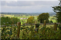
5
Wigtownshire Railway trackbed
North of Borrowmoss Bridge.
Image: © Richard Webb
Taken: 15 Jun 2022
0.22 miles