IMAGES TAKEN NEAR TO
Port William, NEWTON STEWART, DG8 9LA
Introduction
This page details the photographs taken nearby to DG8 9LA by members of the Geograph project.
The Geograph project started in 2005 with the aim of publishing, organising and preserving representative images for every square kilometre of Great Britain, Ireland and the Isle of Man.

There are currently over 7.5m images from over14,400 individuals and you can help contribute to the project by visiting https://www.geograph.org.uk
Image Map
Images are licensed for reuse under creativecommons.org/licenses/by-sa/2.0
Notes
- Clicking on the map will re-center to the selected point.
- The higher the marker number, the further away the image location is from the centre of the postcode.
Image Listing (17 Images Found)
Images are licensed for reuse under creativecommons.org/licenses/by-sa/2.0
Image
Details
Distance
1
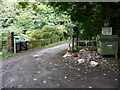
Monreith Estate
View of the road that leads to the estate which includes Monreith House, now holiday flats, and the White Loch of Myrton.
Image: © Andy Farrington
Taken: 28 Aug 2010
0.01 miles
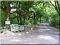
2
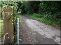
Monreith Estate
Entrance road to the estate with new and old gate posts. The Maxwell Coat of Arms appears on the stone post and South Lodge Cottage is left of this road out of shot.
Image: © Andy Farrington
Taken: 28 Aug 2010
0.01 miles
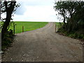
3
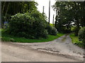
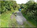
The Airlour
View of the entrance road to this farm which sits in the middle of Airlour Wood.
Image: © Andy Farrington
Taken: 28 Aug 2010
0.01 miles
4
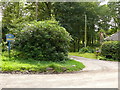
The Airlour
Access road to the farm which runs past Airlour Lodge right of picture.
Image: © Andy Farrington
Taken: 28 Aug 2010
0.01 miles
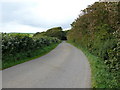
5
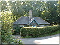
Lodge at Monreith
There are two lodges here, on opposite sides of the road. This is on the western side, controlling access to a separate area of parkland to the main estate.
Image: © David Medcalf
Taken: 15 Jul 2006
0.03 miles
6
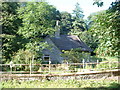
Lodge to the main estate at Monreith
On the eastern side of the road.
Image: © David Medcalf
Taken: 15 Jul 2006
0.03 miles
7
Monreith Estate
View from the entrance to the estate along this unnamed road which runs past the Barsalloch Farms down to Monreith in this direction.
Image: © Andy Farrington
Taken: 28 Aug 2010
0.05 miles
8
North Barsalloch Farm
This new road (seen here right of picture Image) has been completed recently and cuts a swathe across fields along the side of Jasper's Plantation. It also cuts through the access road to the farm which itself runs across three grid squares, NX3542, NX3442 and NX3441.
Image: © Andy Farrington
Taken: 28 Aug 2010
0.16 miles
9
Road Closed
This short road of about 100 yards joins the unnamed road to Monreith with the B7085 and can be seen on OS Mapping. Concrete posts and a fence have been in place at one time to stop access, however the centre post is now broken and in the road way, allowing the large agricultural HGV to park up on the road.
Image: © Andy Farrington
Taken: 28 Aug 2010
0.17 miles
10
The Pheasantry
View from this cottage towards Jasper's Plantation.
Image: © Andy Farrington
Taken: 28 Aug 2010
0.19 miles