IMAGES TAKEN NEAR TO
Whithorn, NEWTON STEWART, DG8 8HX
Introduction
This page details the photographs taken nearby to DG8 8HX by members of the Geograph project.
The Geograph project started in 2005 with the aim of publishing, organising and preserving representative images for every square kilometre of Great Britain, Ireland and the Isle of Man.

There are currently over 7.5m images from over14,400 individuals and you can help contribute to the project by visiting https://www.geograph.org.uk
Image Map (Loading...)


Getting Data...Please wait
Leaflet Map data © OpenStreetMap
Images are licensed for reuse under creativecommons.org/licenses/by-sa/2.0
Notes
- Clicking on the map will re-center to the selected point.
- The higher the marker number, the further away the image location is from the centre of the postcode.
Image Listing (10 Images Found)
Images are licensed for reuse under creativecommons.org/licenses/by-sa/2.0
Image
Details
Distance
1
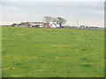
Low Balcray Farm
View across open farmland to this farm off the B7004.
Image: © Andy Farrington
Taken: 16 Nov 2010
0.05 miles
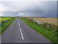
2
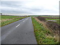
B7004 to the Isle of Whithorn
View along this road past Low Balcray Cottage left of picture.
Image: © Andy Farrington
Taken: 16 Nov 2010
0.15 miles
4
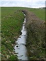
Mother Water
View along this burn at the side of the B7004, left of picture on the horizon is High Balcray Farm.
Image: © Andy Farrington
Taken: 16 Nov 2010
0.18 miles
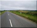
5
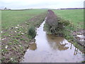
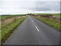
The B7004 Between Whithorn and the Isle of Whithorn
Image: © Mark McKie
Taken: 17 Sep 2007
0.20 miles
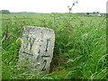
8
Balcray milestone - detail
Yes - it really is this wonky.
Image: © Richard Law
Taken: 9 Aug 2009
0.22 miles
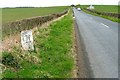
9
B7004 to Whithorn
View along this road past High Balcray Cottage right of picture.
Image: © Andy Farrington
Taken: 16 Nov 2010
0.23 miles
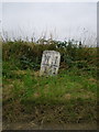
10
Old Milestone by the B7004, south of Whithorn
By the B7004, in parish of Whithorn (Wigtownshire District), halfway between two cottages, on verge.
Inscription reads:- : W (Whithorn) / 1 : : I (Isle of Whithorn) / 2 :
Surveyed
Milestone Society National ID: DG_WHIW01
Image: © Milestone Society
Taken: Unknown
0.24 miles