IMAGES TAKEN NEAR TO
Bridge Street, NEWTON STEWART, DG8 7HY
Introduction
This page details the photographs taken nearby to Bridge Street, DG8 7HY by members of the Geograph project.
The Geograph project started in 2005 with the aim of publishing, organising and preserving representative images for every square kilometre of Great Britain, Ireland and the Isle of Man.

There are currently over 7.5m images from over14,400 individuals and you can help contribute to the project by visiting https://www.geograph.org.uk
Image Map
Images are licensed for reuse under creativecommons.org/licenses/by-sa/2.0
Notes
- Clicking on the map will re-center to the selected point.
- The higher the marker number, the further away the image location is from the centre of the postcode.
Image Listing (236 Images Found)
Images are licensed for reuse under creativecommons.org/licenses/by-sa/2.0
Image
Details
Distance
7
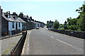
"No Left Turn" on St. John Street
The Hollow is the turning to the left.
Image: © Ann Cook
Taken: 30 Sep 2010
0.03 miles
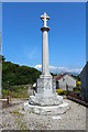
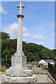
8
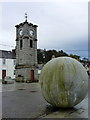
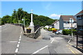
Clock Tower and Sculpture
Adamson Square, Creetown.
Image: © John H Darch
Taken: 19 Oct 2014
0.04 miles
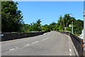
9
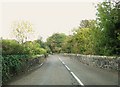
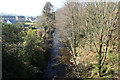
Bridge over the Moneypool Burn
This bridge used to be a nightmare years ago before the Creetown bypass was built. It was a constant hold-up as heavy lorries tried to pass one another in the narrow, twisting space.
Image: © Ann Cook
Taken: 7 Oct 2010
0.04 miles