IMAGES TAKEN NEAR TO
NEWTON STEWART, DG8 6QL
Introduction
This page details the photographs taken nearby to DG8 6QL by members of the Geograph project.
The Geograph project started in 2005 with the aim of publishing, organising and preserving representative images for every square kilometre of Great Britain, Ireland and the Isle of Man.

There are currently over 7.5m images from over14,400 individuals and you can help contribute to the project by visiting https://www.geograph.org.uk
Image Map
Images are licensed for reuse under creativecommons.org/licenses/by-sa/2.0
Notes
- Clicking on the map will re-center to the selected point.
- The higher the marker number, the further away the image location is from the centre of the postcode.
Image Listing (8 Images Found)
Images are licensed for reuse under creativecommons.org/licenses/by-sa/2.0
Image
Details
Distance
1
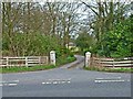
Gateway and driveway to Merton Hall
Adjoining the A75
Image: © Oliver Dixon
Taken: 27 Apr 2006
0.10 miles
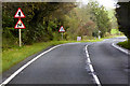
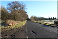
3
Benfield
View along the A75 in the direction of Newton Stewart.
Image: © Andy Farrington
Taken: 4 Nov 2010
0.19 miles
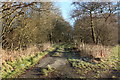
4
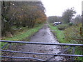
Benfield
This road now blocked off was the original A75 before a new section was built to manage increased traffic to and from Stranraer.
Image: © Andy Farrington
Taken: 4 Nov 2010
0.19 miles
5
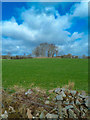
Copse with Issues
South of Blackpark Farm, OS mapping describes the wooded area as having issues which I had to look up (A point where water issues from the ground, eg. a spring), seen here from the side of the A75.
Image: © Andy Farrington
Taken: 23 Apr 2013
0.21 miles
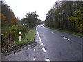
8
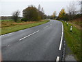
Hazel Green
View along the A75 in the direction of Stranraer.
Image: © Andy Farrington
Taken: 4 Nov 2010
0.25 miles