IMAGES TAKEN NEAR TO
Glenluce, NEWTON STEWART, DG8 0NP
Introduction
This page details the photographs taken nearby to DG8 0NP by members of the Geograph project.
The Geograph project started in 2005 with the aim of publishing, organising and preserving representative images for every square kilometre of Great Britain, Ireland and the Isle of Man.

There are currently over 7.5m images from over14,400 individuals and you can help contribute to the project by visiting https://www.geograph.org.uk
Image Map
Images are licensed for reuse under creativecommons.org/licenses/by-sa/2.0
Notes
- Clicking on the map will re-center to the selected point.
- The higher the marker number, the further away the image location is from the centre of the postcode.
Image Listing (5 Images Found)
Images are licensed for reuse under creativecommons.org/licenses/by-sa/2.0
Image
Details
Distance
1
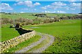
Valley of Water of Luce
View from the track to Airyhemming Farm over the valley towards Balmesh Farm.
Image: © Andy Farrington
Taken: 23 Mar 2014
0.07 miles
2
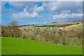
Airyhemming
View north east from the track to the farm, over the Water of Luce.
Image: © Andy Farrington
Taken: 23 Mar 2014
0.11 miles
3
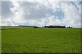
Farmland by Airyhemming
Looking west over grazing fields by the farm.
Image: © Andy Farrington
Taken: 23 Mar 2014
0.13 miles
4
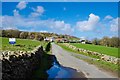
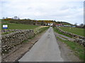
Airyhemming Farm
Track to the farm.
Image: © Andy Farrington
Taken: 23 Mar 2014
0.15 miles
5
Airyhemming Farm
Airyhemming farm is situated northwest of Glenluce Abbey in an area notable for archaeological sites.
Image: © Chris Newman
Taken: 9 Apr 2008
0.24 miles