IMAGES TAKEN NEAR TO
New Luce, NEWTON STEWART, DG8 0LU
Introduction
This page details the photographs taken nearby to DG8 0LU by members of the Geograph project.
The Geograph project started in 2005 with the aim of publishing, organising and preserving representative images for every square kilometre of Great Britain, Ireland and the Isle of Man.

There are currently over 7.5m images from over14,400 individuals and you can help contribute to the project by visiting https://www.geograph.org.uk
Image Map
Images are licensed for reuse under creativecommons.org/licenses/by-sa/2.0
Notes
- Clicking on the map will re-center to the selected point.
- The higher the marker number, the further away the image location is from the centre of the postcode.
Image Listing (3 Images Found)
Images are licensed for reuse under creativecommons.org/licenses/by-sa/2.0
Image
Details
Distance
1
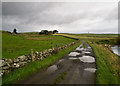
Quarter Farm
'Quarter' or 'quarterland' is an old Scots division of land (in Gaelic ceathramh), equivalent to eight fourpennylands or a quarter of an ounceland, which was itself was an eighth of a markland. A markland was an area of land for which the annual rent was one mark (worth about 13s 4d).
To the right of the farm road runs the Cross Water of Luce.
Image: © David Baird
Taken: 5 Sep 2009
0.00 miles
2
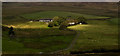
Quarter
Quarter - so named from an old Scots land measure (quarterland).
Image: © David Baird
Taken: 5 Sep 2009
0.01 miles
3
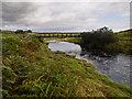
Quarter Bridge
Carrying the farm road to Quarter farm over the Cross Water of Luce.
Image: © David Baird
Taken: 5 Sep 2009
0.22 miles