IMAGES TAKEN NEAR TO
Auchenmalg, Glenluce, NEWTON STEWART, DG8 0JY
Introduction
This page details the photographs taken nearby to DG8 0JY by members of the Geograph project.
The Geograph project started in 2005 with the aim of publishing, organising and preserving representative images for every square kilometre of Great Britain, Ireland and the Isle of Man.

There are currently over 7.5m images from over14,400 individuals and you can help contribute to the project by visiting https://www.geograph.org.uk
Image Map
Images are licensed for reuse under creativecommons.org/licenses/by-sa/2.0
Notes
- Clicking on the map will re-center to the selected point.
- The higher the marker number, the further away the image location is from the centre of the postcode.
Image Listing (31 Images Found)
Images are licensed for reuse under creativecommons.org/licenses/by-sa/2.0
Image
Details
Distance
1
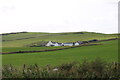
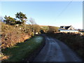
Long Forth Farm, Auchenmalg
Viewed from the A747.
Image: © Billy McCrorie
Taken: 10 Oct 2021
0.02 miles
6
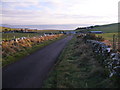
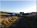
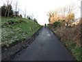
Longforth
View along this small road that runs between Glenluce and Auchenmalg. Centre of picture is Longforth Farm, Luce Bay and the Mull of Galloway.
Image: © Andy Farrington
Taken: 13 Dec 2010
0.12 miles
7
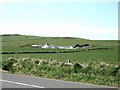
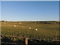
Fields beside the A747
This view, overlooking the fields, was taken from the lay-by near the community hall. The farm in the distance is Long Forth.
Image: © Ann Cook
Taken: 21 Apr 2010
0.12 miles
10
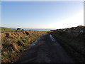
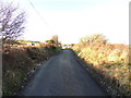
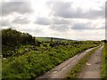
Road to Auchenmalg
With view of Auchenmalg Bay.
Image: © Billy McCrorie
Taken: 10 Dec 2012
0.16 miles