IMAGES TAKEN NEAR TO
Dalry, CASTLE DOUGLAS, DG7 3TA
Introduction
This page details the photographs taken nearby to DG7 3TA by members of the Geograph project.
The Geograph project started in 2005 with the aim of publishing, organising and preserving representative images for every square kilometre of Great Britain, Ireland and the Isle of Man.

There are currently over 7.5m images from over14,400 individuals and you can help contribute to the project by visiting https://www.geograph.org.uk
Image Map
Images are licensed for reuse under creativecommons.org/licenses/by-sa/2.0
Notes
- Clicking on the map will re-center to the selected point.
- The higher the marker number, the further away the image location is from the centre of the postcode.
Image Listing (13 Images Found)
Images are licensed for reuse under creativecommons.org/licenses/by-sa/2.0
Image
Details
Distance
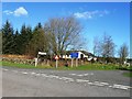
4
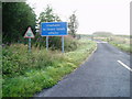
Junction Road signs.
Warning signs at the junction of the unclassified road and A713.
Image: © Bob Peace
Taken: 8 Aug 2007
0.08 miles
5
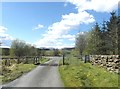
A cattle grid just before the A713
This is where the unclassified road from Kendoon Loch joins the A713.
Image: © Ann Cook
Taken: 17 May 2013
0.08 miles
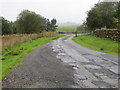
6
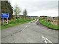
Unsuitable for heavy goods vehicles
This unclassified road leads from the A713 to the B729.
Image: © Ann Cook
Taken: 12 May 2013
0.09 miles
7
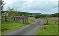
This way to Carminnows
This minor road connects the A713 with the B729 on the other side of Kendoon Loch.
Image: © Mary and Angus Hogg
Taken: 3 Aug 2019
0.09 miles
8
Road to A713 at High Carminnows
Looking north-westward.
Image: © Peter Wood
Taken: 12 Sep 2017
0.10 miles
9
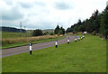
On the A713
Viewed at Polquhanity, showing both the old and the new power lines on the other side of the road.
Image: © Mary and Angus Hogg
Taken: 3 Aug 2019
0.12 miles