IMAGES TAKEN NEAR TO
New Galloway, CASTLE DOUGLAS, DG7 3SE
Introduction
This page details the photographs taken nearby to DG7 3SE by members of the Geograph project.
The Geograph project started in 2005 with the aim of publishing, organising and preserving representative images for every square kilometre of Great Britain, Ireland and the Isle of Man.

There are currently over 7.5m images from over14,400 individuals and you can help contribute to the project by visiting https://www.geograph.org.uk
Image Map
Images are licensed for reuse under creativecommons.org/licenses/by-sa/2.0
Notes
- Clicking on the map will re-center to the selected point.
- The higher the marker number, the further away the image location is from the centre of the postcode.
Image Listing (13 Images Found)
Images are licensed for reuse under creativecommons.org/licenses/by-sa/2.0
Image
Details
Distance
1
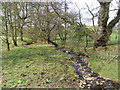
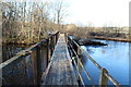
Finlay's Burn
Near the edge of the square opposite Gaistone Brae.
Image: © Walter Baxter
Taken: 28 Apr 2007
0.09 miles
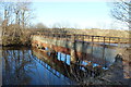
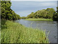
2
Beside the Water of Ken
Scattered oaks just over a flood defence berm from the river at its confluence with burns and outflow from Glenlee Power Station.
Image: © Richard Webb
Taken: 19 Jan 2020
0.10 miles
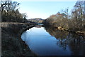
7
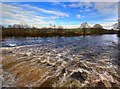
River Ken, with water from Glenlee Tailrace Emerging In The Foreground
Image: © Duncan McNaught
Taken: 31 Jan 2009
0.18 miles
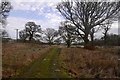
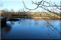
8
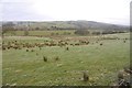
Fields, Shiel
Above the Meikle Isle and Water of Ken.
Image: © Richard Webb
Taken: 19 Jan 2020
0.19 miles
9
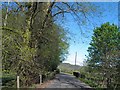
A not so busy A762 near Coom Bridge
In the tree a red squirrel was watching.
Image: © Steve Fareham
Taken: 21 May 2013
0.20 miles