IMAGES TAKEN NEAR TO
Corsock, CASTLE DOUGLAS, DG7 3EA
Introduction
This page details the photographs taken nearby to DG7 3EA by members of the Geograph project.
The Geograph project started in 2005 with the aim of publishing, organising and preserving representative images for every square kilometre of Great Britain, Ireland and the Isle of Man.

There are currently over 7.5m images from over14,400 individuals and you can help contribute to the project by visiting https://www.geograph.org.uk
Image Map
Images are licensed for reuse under creativecommons.org/licenses/by-sa/2.0
Notes
- Clicking on the map will re-center to the selected point.
- The higher the marker number, the further away the image location is from the centre of the postcode.
Image Listing (7 Images Found)
Images are licensed for reuse under creativecommons.org/licenses/by-sa/2.0
Image
Details
Distance
2
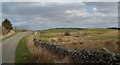
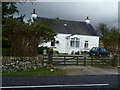
The A712
Looking west-northwest along the A712 near Bread and Beer Cottage.
Image: © Walter Baxter
Taken: 28 Apr 2007
0.07 miles
3
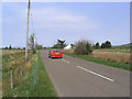
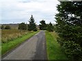
Approaching Bread and Beer Cottage on the A712
Image: © Bob Peace
Taken: 19 Sep 2011
0.09 miles
6
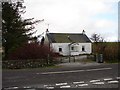
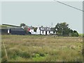
Bread & Beer Cottage
Bread & Beer Cottage, A712 E of Balmaclellan and W of Corsock. Name originates from being a drover's stop, although not known to have been an inn. Road behind photograph is north end of "The Hidden Road".
Image: © Chris Newman
Taken: 28 Jan 2008
0.16 miles