IMAGES TAKEN NEAR TO
Merse Strand, KIRKCUDBRIGHT, DG6 4RU
Introduction
This page details the photographs taken nearby to Merse Strand, DG6 4RU by members of the Geograph project.
The Geograph project started in 2005 with the aim of publishing, organising and preserving representative images for every square kilometre of Great Britain, Ireland and the Isle of Man.

There are currently over 7.5m images from over14,400 individuals and you can help contribute to the project by visiting https://www.geograph.org.uk
Image Map
Images are licensed for reuse under creativecommons.org/licenses/by-sa/2.0
Notes
- Clicking on the map will re-center to the selected point.
- The higher the marker number, the further away the image location is from the centre of the postcode.
Image Listing (20 Images Found)
Images are licensed for reuse under creativecommons.org/licenses/by-sa/2.0
Image
Details
Distance
1
Mersecroft, Kirkcudbright, seen from the A755
Image: © habiloid
Taken: 28 Jul 2021
0.05 miles

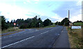
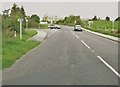
3

Leaving Kirkcudbright
Going towards Gatehouse of Fleet.
Image: © Billy McCrorie
Taken: 27 Jun 2014
0.11 miles
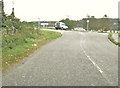
4
Approaching the turning to Borgue on the A755
Merse Avenue can just be seen on the right.
Image: © Ann Cook
Taken: 18 Sep 2010
0.11 miles

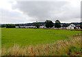
9
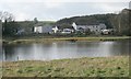
Houses beside the River Dee, Mersecroft, Kirkcudbright
Image: © Richard Sutcliffe
Taken: 26 Oct 2017
0.15 miles
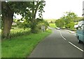
10
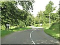
The Stell, Kirkcudbright
This is the B727 as it passes through an area known as The Stell.
Image: © Ann Cook
Taken: 18 Sep 2010
0.17 miles