IMAGES TAKEN NEAR TO
KIRKCUDBRIGHT, DG6 4QB
Introduction
This page details the photographs taken nearby to DG6 4QB by members of the Geograph project.
The Geograph project started in 2005 with the aim of publishing, organising and preserving representative images for every square kilometre of Great Britain, Ireland and the Isle of Man.

There are currently over 7.5m images from over14,400 individuals and you can help contribute to the project by visiting https://www.geograph.org.uk
Image Map
Images are licensed for reuse under creativecommons.org/licenses/by-sa/2.0
Notes
- Clicking on the map will re-center to the selected point.
- The higher the marker number, the further away the image location is from the centre of the postcode.
Image Listing (4 Images Found)
Images are licensed for reuse under creativecommons.org/licenses/by-sa/2.0
Image
Details
Distance
1
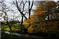
The Buckland Burn
The burn about 150 yards from the bridge, on the road to Corbie Nest.
Image: © Dave Durie
Taken: 20 Nov 2006
0.09 miles
4
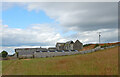
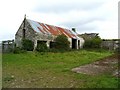
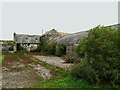
High Banks Steading, nr Kirkcudbright
Now in ruins, High Banks Steading dates back to before 1850. The wooden stables in the foreground were built about 2018. To the NW is High Banks House.
Image: © Forrest and Jen
Taken: 1 Aug 2021
0.17 miles