IMAGES TAKEN NEAR TO
Twynholm, KIRKCUDBRIGHT, DG6 4PS
Introduction
This page details the photographs taken nearby to DG6 4PS by members of the Geograph project.
The Geograph project started in 2005 with the aim of publishing, organising and preserving representative images for every square kilometre of Great Britain, Ireland and the Isle of Man.

There are currently over 7.5m images from over14,400 individuals and you can help contribute to the project by visiting https://www.geograph.org.uk
Image Map
Images are licensed for reuse under creativecommons.org/licenses/by-sa/2.0
Notes
- Clicking on the map will re-center to the selected point.
- The higher the marker number, the further away the image location is from the centre of the postcode.
Image Listing (7 Images Found)
Images are licensed for reuse under creativecommons.org/licenses/by-sa/2.0
Image
Details
Distance
1

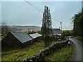
Glengap Farm
The road to Glengap is deeply shaded by the forest. Behind the house is seen Dow Craig Hill and the cliffs of Dow Craig.
Image: © James Bell
Taken: 19 Aug 2010
0.02 miles
2
Glengap
View of the farm that is about 5km from the A75 by the Fore Hill of Glengap.
Image: © Andy Farrington
Taken: 28 Jan 2014
0.03 miles
3
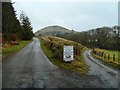
Lairdmannoch Estate and Mielfield Farm
The road off to the right leads to the estate and farm, left is the road to dwelling by Gordons Cairn and Glengap Forest. Centre horizon is Dow Craig Hill.
Image: © Andy Farrington
Taken: 28 Jan 2014
0.05 miles
4
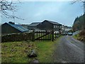
Dwellings by Gordons Cairn
Picture of a row of properties at the end of a track that is about 5km from the A75 making them quite isolated.
Image: © Andy Farrington
Taken: 28 Jan 2014
0.16 miles

6
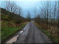
Gordons Cairn
The road from the A75 ends at this point and becomes a forest track in to Glengap and Laurieston Forests.
Image: © Andy Farrington
Taken: 28 Jan 2014
0.19 miles
7
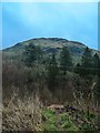
Dow Craig Hill
View to the hill north east from the track at the start of Glengap Forest.
Image: © Andy Farrington
Taken: 28 Jan 2014
0.21 miles