IMAGES TAKEN NEAR TO
Enterkinfoot, THORNHILL, DG3 5BZ
Introduction
This page details the photographs taken nearby to DG3 5BZ by members of the Geograph project.
The Geograph project started in 2005 with the aim of publishing, organising and preserving representative images for every square kilometre of Great Britain, Ireland and the Isle of Man.

There are currently over 7.5m images from over14,400 individuals and you can help contribute to the project by visiting https://www.geograph.org.uk
Image Map
Images are licensed for reuse under creativecommons.org/licenses/by-sa/2.0
Notes
- Clicking on the map will re-center to the selected point.
- The higher the marker number, the further away the image location is from the centre of the postcode.
Image Listing (4 Images Found)
Images are licensed for reuse under creativecommons.org/licenses/by-sa/2.0
Image
Details
Distance
1
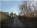
Coshogle Cottages
Houses on the rough dead-end road which leads from the A76 up to the farm at Coshogle.
Image: © Alan O'Dowd
Taken: 21 Jan 2017
0.00 miles
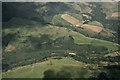
2

Bend on road to Coshogle
The rough dead-end road up from the A76 to the farm at Coshogle winds round in a hairpin bend. The house visible here is a modern house adjacent to Coshogle Cottages.
Image: © Alan O'Dowd
Taken: 21 Jan 2017
0.07 miles
4
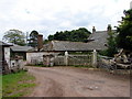
Coshogle Farm
The lane from the Enterkinfoot (A76) climbs and winds up to Coshogle, site of a castle, but now just a neglected farmyard with the farmhouse mainly hidden behind the farm buildings.
Image: © Chris Newman
Taken: 4 Jul 2008
0.19 miles