IMAGES TAKEN NEAR TO
THORNHILL, DG3 4NN
Introduction
This page details the photographs taken nearby to DG3 4NN by members of the Geograph project.
The Geograph project started in 2005 with the aim of publishing, organising and preserving representative images for every square kilometre of Great Britain, Ireland and the Isle of Man.

There are currently over 7.5m images from over14,400 individuals and you can help contribute to the project by visiting https://www.geograph.org.uk
Image Map
Images are licensed for reuse under creativecommons.org/licenses/by-sa/2.0
Notes
- Clicking on the map will re-center to the selected point.
- The higher the marker number, the further away the image location is from the centre of the postcode.
Image Listing (5 Images Found)
Images are licensed for reuse under creativecommons.org/licenses/by-sa/2.0
Image
Details
Distance
1
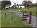
Dalgonar
The second highest house in the Scaur Water Glen.
Image: © Oliver Dixon
Taken: 22 Oct 2009
0.01 miles
2
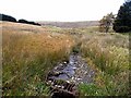
Dalgonar Cleuch
A tributary of the Scaur Water. Rough Shoulder in the background.
Image: © Oliver Dixon
Taken: 22 Oct 2009
0.03 miles
3
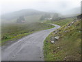
Southern Upland Way on road towards Dalgonar
Image: © Chris Wimbush
Taken: 2 Sep 2006
0.08 miles
4
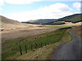
Dalgonar Fields
The Scaur Water Glen road descends towards the grazing fields of Dalgonar between Polgown and Polskeoch. In the distance is the Polskeoch Forest.
Image: © Chris Newman
Taken: 11 Apr 2009
0.19 miles
5
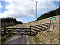
Polskeoch Forest - East
The 10 mile long Scaur Water Glen road enters the Polskeoch Forest between Polgown and Polskeoch, this section of road is shared with the Southern Upland Way long-distance walk.
Image: © Chris Newman
Taken: 11 Apr 2009
0.22 miles