IMAGES TAKEN NEAR TO
Irongray, DUMFRIES, DG2 9TT
Introduction
This page details the photographs taken nearby to DG2 9TT by members of the Geograph project.
The Geograph project started in 2005 with the aim of publishing, organising and preserving representative images for every square kilometre of Great Britain, Ireland and the Isle of Man.

There are currently over 7.5m images from over14,400 individuals and you can help contribute to the project by visiting https://www.geograph.org.uk
Image Map
Images are licensed for reuse under creativecommons.org/licenses/by-sa/2.0
Notes
- Clicking on the map will re-center to the selected point.
- The higher the marker number, the further away the image location is from the centre of the postcode.
Image Listing (16 Images Found)
Images are licensed for reuse under creativecommons.org/licenses/by-sa/2.0
Image
Details
Distance
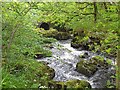
5
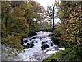
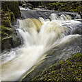
Routin Bridge
This is the view looking south west from the bridge in October 2004. Salmon leap the falls at this time of year
Image: © David Grimshaw
Taken: 25 Oct 2004
0.16 miles
6
At The Routin' Bridge
At the Routin' Bridge - Irongray.
Check it out on my Flickr page.
https://flic.kr/p/R1gN57
Image: © James Johnstone
Taken: 3 May 2016
0.17 miles
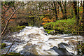
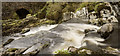
7
Old Water Near Routin Bridge
This is just below the falls at Routin Bridge
Image: © Iain Thompson
Taken: 21 Dec 2007
0.17 miles
8
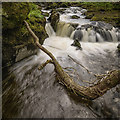
Fallen
Check it out on my Flickr page.
www.flickr.com/photos/jetjohn/32819058425/in/dateposted-public/
At the Routin' Bridge - Irongray.
Image: © James Johnstone
Taken: 3 May 2016
0.17 miles
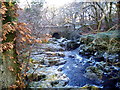
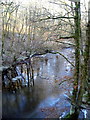
9
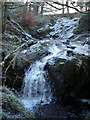
Falls at Routin Bridge
The rocks and vegetation are covered in frost.
Image: © Iain Thompson
Taken: 21 Dec 2007
0.17 miles
10
Torrent
Check it out on my Flickr page.
www.flickr.com/photos/jetjohn/32467318296/in/dateposted-public/
At the Routin' Bridge - Irongray.
The only river strictly belonging to the parish is the Auld, which has its source on the confines of Kirkpatrick-Durham, and, after flowing for some miles through this parish in an eastern course, curves towards the north, and falls into the Cairn, which, afterwards taking the name of the Cluden, forms a boundary of the parish. The Auld water, near its influx into the Cairn, makes a small but picturesque cascade of two falls, the highest of which is twenty feet; and near the lower fall is a romantic bridge of one arch, which, from the noise of the water, has obtained the appellation of the Routing Bridge.
The above description is taken from "A Topographical Dictionary of Scotland" by Samuel Lewis, published in 1846.
Image: © James Johnstone
Taken: 3 May 2016
0.17 miles