IMAGES TAKEN NEAR TO
Crocketford, DUMFRIES, DG2 8RJ
Introduction
This page details the photographs taken nearby to DG2 8RJ by members of the Geograph project.
The Geograph project started in 2005 with the aim of publishing, organising and preserving representative images for every square kilometre of Great Britain, Ireland and the Isle of Man.

There are currently over 7.5m images from over14,400 individuals and you can help contribute to the project by visiting https://www.geograph.org.uk
Image Map
Images are licensed for reuse under creativecommons.org/licenses/by-sa/2.0
Notes
- Clicking on the map will re-center to the selected point.
- The higher the marker number, the further away the image location is from the centre of the postcode.
Image Listing (11 Images Found)
Images are licensed for reuse under creativecommons.org/licenses/by-sa/2.0
Image
Details
Distance
1
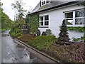
Stonecraft, Beech Cottage, Crocketford
These structures composed of slate or similar material adorn the front of Beech Cottage at Crocketford which is the home of a stonemason.
Image: © Oliver Dixon
Taken: 23 May 2009
0.02 miles
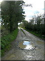
2
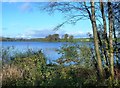
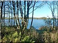
Milton Loch Shoreline
Looking towards Milton Loch, which lies in the next square, from a clear space on the wooded southern shoreline. The loch is a kettle lake, created when a huge block of ice became stuck below the moving ice sheet which continued to lay down deposits around it.
Image: © Mary and Angus Hogg
Taken: 29 Oct 2013
0.02 miles
3
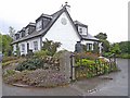
Beech Cottage, Crocketford
This house on the southern shores of Milton Loch near Crocketford is home and workshop of a stonemason.
Image: © Oliver Dixon
Taken: 23 May 2009
0.02 miles
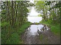
4
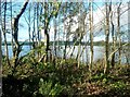
Milton Loch View
Looking through the woodland on the southern shoreline of Milton Loch, which lies in the next square. This late-October view was taken when the trees had lost most of their foliage. The loch is a kettle lake, created when a huge block of ice became stuck below the moving ice sheet which continued to lay down deposits around it.
Image: © Mary and Angus Hogg
Taken: 29 Oct 2013
0.04 miles
6
Milton Loch, Crocketford
Roads run close to the southern and south-eastern shores of Milton Loch, but this appears to be the only spot where it is easy to get down to the shore.
Image: © Oliver Dixon
Taken: 23 May 2009
0.08 miles
7
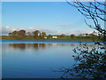
Milton Loch
Milton Loch, viewed from the southern shore in late-October. This loch is a kettle lake, produced during the last Ice Age when a huge block of ice became detached from the rest of the ice sheet, which continued to deposit glacial till around it. The farm on the other side lies in the next square.
Image: © Mary and Angus Hogg
Taken: 29 Oct 2013
0.09 miles
8
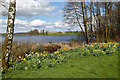
Milton Loch
Looking out over Milton Loch near Crocketford.
Image: © Colin Kinnear
Taken: 12 Apr 2021
0.09 miles
9
Milton Loch
The loch was viewed from the roadside opposite Beech Cottage.
Image: © Walter Baxter
Taken: 20 Apr 2018
0.10 miles
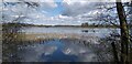
10
Milton Loch Shore
Looking through the woodland strip on the southern shore of Milton Loch on a blustery late-October afternoon. Most of the loch lies in the next square.
Image: © Mary and Angus Hogg
Taken: 29 Oct 2013
0.12 miles