IMAGES TAKEN NEAR TO
Kirkgunzeon, DUMFRIES, DG2 8JW
Introduction
This page details the photographs taken nearby to DG2 8JW by members of the Geograph project.
The Geograph project started in 2005 with the aim of publishing, organising and preserving representative images for every square kilometre of Great Britain, Ireland and the Isle of Man.

There are currently over 7.5m images from over14,400 individuals and you can help contribute to the project by visiting https://www.geograph.org.uk
Image Map
Images are licensed for reuse under creativecommons.org/licenses/by-sa/2.0
Notes
- Clicking on the map will re-center to the selected point.
- The higher the marker number, the further away the image location is from the centre of the postcode.
Image Listing (6 Images Found)
Images are licensed for reuse under creativecommons.org/licenses/by-sa/2.0
Image
Details
Distance
1
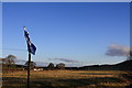
Saltire and Sunlight
A saltire flag behind Toll Bar Cottage, with early morning sunshine on the fields beyond. The slopes to the right are the start of Lotus Hill.
Image: © Colin Kinnear
Taken: 25 Nov 2010
0.08 miles
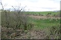
2
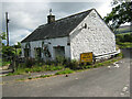
Former tollhouse
Surveyed by the Milestone Society. On the A711 from Dumfries to Dalbeattie at a minor road to Breconside and at the side of Glaisters Burn. On an 1852 map noted as PO. It was either erected by the Dalbeattie Trust or they utilised a cottage already there.
Image: © Alverie Weighill
Taken: 29 Aug 2011
0.11 miles
3
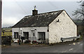
Toll Bar Cottage
Toll Bar Cottage stands at the junction of the A711 and a minor road to the east; OS. flush bracket G124 is on the gable end - hard to detect in this image and hard to read due to a heavy coat of paint.
Image: © Trevor Littlewood
Taken: 12 Feb 2011
0.12 miles
4
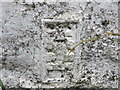
Ordnance Survey Flush Bracket G124
This can be found on the wall of Tollbar Cottage.
For more detail see : http://www.bench-marks.org.uk/bm16692
Image: © Peter Wood
Taken: 27 Sep 2013
0.13 miles
6
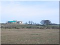
Drumjohn.
Building work at the farm, possibly steading conversion
Image: © Richard Webb
Taken: 5 Mar 2006
0.18 miles