IMAGES TAKEN NEAR TO
Ryedale Terrace, DUMFRIES, DG2 7DL
Introduction
This page details the photographs taken nearby to Ryedale Terrace, DG2 7DL by members of the Geograph project.
The Geograph project started in 2005 with the aim of publishing, organising and preserving representative images for every square kilometre of Great Britain, Ireland and the Isle of Man.

There are currently over 7.5m images from over14,400 individuals and you can help contribute to the project by visiting https://www.geograph.org.uk
Image Map
Images are licensed for reuse under creativecommons.org/licenses/by-sa/2.0
Notes
- Clicking on the map will re-center to the selected point.
- The higher the marker number, the further away the image location is from the centre of the postcode.
Image Listing (165 Images Found)
Images are licensed for reuse under creativecommons.org/licenses/by-sa/2.0
Image
Details
Distance

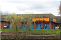
4
J B Stevenson & Jeffrey Ltd,Dumfries
Image: © Billy McCrorie
Taken: 17 Apr 2017
0.09 miles
5
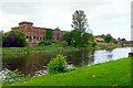
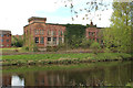
View of Rosefield Mills from Dock Park
This imposing building beside the River Nith was part of a large tweed mill, in 1906 over 700 people were employed here (history of tweed manufacturing in Nithsdale - see Future Museum http://futuremuseum.co.uk/collections/life-work/key-industries/textiles/tweed-manufacturing-in-nithsdale.aspx ).
Production changed to military cloth during the First World War, after which the company failed to compete in the new markets and did not survive the Depression (see Dumfries Museum http://www.dumfriesmuseum.demon.co.uk/dumfstory06.html ).
The site passed into multiple occupation, the main building has been deteriorating over a number of years and appears to be unoccupied - see Image .
Aerial photos showing the extent of the mill in 1928 can be seen on Canmore http://canmore.rcahms.gov.uk/en/site/68566/details/dumfries+troqueer+road+rosefield+mills/
Image: © Rose and Trev Clough
Taken: 9 Jun 2012
0.09 miles
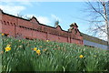
6
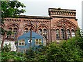
Rosefield Mills - a building at risk
End bay of the building shown here Image .
This former tweed mill, dated 1886, is a Category B listed building. Most of the windows are broken and plants are growing on and over the structure. It is on the Buildings at Risk Register for Scotland http://www.buildingsatrisk.org.uk/search/planning_authority/182/page/4/event_id/891211/building_name/rosefield-mills-riverside-mill-troqueer-road-dumfries .
For further information see Image
Image: © Rose and Trev Clough
Taken: 9 Jun 2012
0.10 miles
8
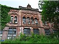
Rosefield Mills - elaborate riverside facade
Dumfries was a major producer of tweed in the late 19th/early 20th centuries. Rosefield, opened in 1885 by Charteries Spence & Co., was the largest mill in the area.
The date 1886 is carved on the parapet. The Historic Scotland listed building description gives detailed architectural information http://hsewsf.sedsh.gov.uk/hslive/portal.hsstart?P_HBNUM=26348 .
Tweed production ceased around the 1930s, the mill buildings were adapted to other uses but have been decaying for many years.
Image: © Rose and Trev Clough
Taken: 9 Jun 2012
0.10 miles
9

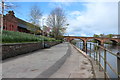
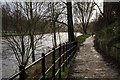
Path Alongside the River Nith at Dumfries
Image: © David Dixon
Taken: 14 Feb 2013
0.10 miles