IMAGES TAKEN NEAR TO
Dunscore, DUMFRIES, DG2 0UU
Introduction
This page details the photographs taken nearby to DG2 0UU by members of the Geograph project.
The Geograph project started in 2005 with the aim of publishing, organising and preserving representative images for every square kilometre of Great Britain, Ireland and the Isle of Man.

There are currently over 7.5m images from over14,400 individuals and you can help contribute to the project by visiting https://www.geograph.org.uk
Image Map
Images are licensed for reuse under creativecommons.org/licenses/by-sa/2.0
Notes
- Clicking on the map will re-center to the selected point.
- The higher the marker number, the further away the image location is from the centre of the postcode.
Image Listing (3 Images Found)
Images are licensed for reuse under creativecommons.org/licenses/by-sa/2.0
Image
Details
Distance
1
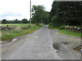
Road at the entrance to Sundaywell
Looking eastward.
Image: © Peter Wood
Taken: 16 Sep 2017
0.01 miles
2
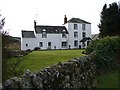
Sundaywell
Sundaywell Tower dates from 1651, it was converted to form part of farmhouse in late C18. There are a number of archaeological sites in the surrounding area.
Image: © Chris Newman
Taken: 24 Feb 2008
0.01 miles