
IMAGES TAKEN NEAR TO
Glencaple Avenue, DUMFRIES, DG1 4SH
Introduction
This page details the photographs taken nearby to Glencaple Avenue, DG1 4SH by members of the Geograph project.
The Geograph project started in 2005 with the aim of publishing, organising and preserving representative images for every square kilometre of Great Britain, Ireland and the Isle of Man.

There are currently over 7.5m images from over14,400 individuals and you can help contribute to the project by visiting https://www.geograph.org.uk
Image Map
Images are licensed for reuse under creativecommons.org/licenses/by-sa/2.0
Notes
- Clicking on the map will re-center to the selected point.
- The higher the marker number, the further away the image location is from the centre of the postcode.
Image Listing (43 Images Found)
Images are licensed for reuse under creativecommons.org/licenses/by-sa/2.0
Image
Details
Distance
1
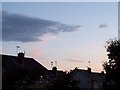
Sunset in Castledykes
This is taken from near the top of Castledykes Road and shows some of the houses on the southern side of the street.
Image: © Mark Toner
Taken: 8 Jul 2008
0.07 miles
2
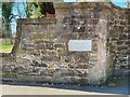
Old Boundary Marker on the B725 Glencaple Road, Dumfries
War Department Boundary Marker set in the outer boundary wall of Hannahfield House on the west side of the B725 Glencaple Road, Dumfries, south of its junction with Glencaple Avenue. Inscribed W ↑ D / No. 5.
The history of Hannahfield House can be read here https://www.buildingsatrisk.org.uk/details/909982. Category B Listed details http://portal.historicenvironment.scot/designation/LB3829.
Milestone Society National ID: DF_WDKING05em
Image: © W MacDonald
Taken: 18 Apr 2021
0.09 miles
3
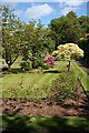
Castledykes Park
The carefully tended rose garden has been created inside the former quarry at Castledykes.
Image: © Anne Burgess
Taken: 22 May 2009
0.10 miles
4
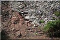
Doweel Breccia
Like the underlying Locharbriggs Sandstone Formation, the Doweel Breccia was formed in a Permian desert. However the breccia was not laid down by wind, but is the debris left by a flash flood following sudden intense rain. The contact between the reddish sandstone and the grey breccia is obvious in this view, taken in the rose garden in Castledykes Park. Sadly, the old quarry face is becoming overgrown, and unless some sort of action is taken it may not be long before the interesting geological features are completely obscured by ivy and other vegetation.
Image: © Anne Burgess
Taken: 22 May 2009
0.11 miles
5
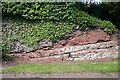
Aeolian Sandstone
The northern face of the former quarry is becoming overgrown, but here there is a good example of the Locharbriggs Sandstone Formation, the same sandstone as that in Locharbriggs quarry. This is New Red Sandstone, laid down as sand dunes in a desert environment during the Permian. (Old Red Sandstone was laid down much earlier, in the Devonian.)
Image: © Anne Burgess
Taken: 22 May 2009
0.11 miles
6
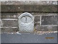
Old Milestone by the B725, Crichton Royal Hospital, Dumfries
Milestone by the B725, in parish of Dumfries (Nithsdale District), South end of Dumfries, 50m South of pelican crossing, in low roadside wall of Crichton Royal Hospital grounds, East side of road.
Inscription reads:-
1
(To Dumfries)
Surveyed
Milestone Society National ID: DG_DFANB01
Image: © Milestone Society
Taken: Unknown
0.12 miles
8
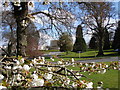
Crichton Grounds, Dumfries
View through Crichton Grounds tree blossom to the west end of the new (2008) Dental Unit of Dumfries & Galloway Royal Infirmary.
Image: © Chris Newman
Taken: 19 Apr 2008
0.16 miles
9

Crichton Royal gardens
Crichton Royal gardens in Dumfries.
Image: © Colin Kinnear
Taken: 22 Apr 2020
0.17 miles
10
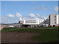
Dumfries & Galloway Royal Infirmary, A&E
Dumfries & Galloway Royal Infirmary A&E and out patients entrances. Helicopter landing pad in foreground. Also see Image
Image: © Chris Newman
Taken: 19 Apr 2008
0.17 miles