IMAGES TAKEN NEAR TO
DUMFRIES, DG1 4QR
Introduction
This page details the photographs taken nearby to DG1 4QR by members of the Geograph project.
The Geograph project started in 2005 with the aim of publishing, organising and preserving representative images for every square kilometre of Great Britain, Ireland and the Isle of Man.

There are currently over 7.5m images from over14,400 individuals and you can help contribute to the project by visiting https://www.geograph.org.uk
Image Map
Images are licensed for reuse under creativecommons.org/licenses/by-sa/2.0
Notes
- Clicking on the map will re-center to the selected point.
- The higher the marker number, the further away the image location is from the centre of the postcode.
Image Listing (8 Images Found)
Images are licensed for reuse under creativecommons.org/licenses/by-sa/2.0
Image
Details
Distance
1
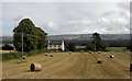
Barnkin of Craigs
Barnkin of Craigs across the fields.
Image: © Colin Kinnear
Taken: 4 Sep 2008
0.00 miles
3
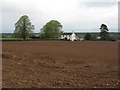
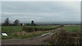
Barnkin of Craigs Farm
The large low-lying plantation of Craigs Moss and Racks Moss can be seen beyond.
Image: © Oliver Dixon
Taken: 2 Sep 2013
0.02 miles
5
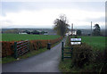
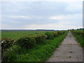
The track to Barnkin of Craigs
Descending from a 31 metre spot height at the crossroads on Craigs Road.
Image: © Christine Johnstone
Taken: 23 Jan 2020
0.09 miles
6
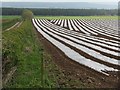
Keeping the tatties warm?
Freshly tilled and covered, and I assume it will be an early potato crop.
Image: © M J Richardson
Taken: 26 Apr 2009
0.15 miles
7
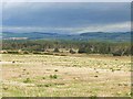
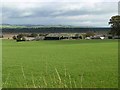
Rough pasture near Barnkin of Craigs
The extensive low-lying plantation of Craigs Moss beyond.
Image: © Oliver Dixon
Taken: 2 Sep 2013
0.16 miles
8
Lower Barnkin
Farm track leads SE from rear of Barnkin Cottages with Craigs Moss to left of picture and Barnkin of Craigs Farm grazing fields over the hedging to right.
Image: © Chris Newman
Taken: 21 May 2008
0.24 miles