IMAGES TAKEN NEAR TO
LANGHOLM, DG13 0HG
Introduction
This page details the photographs taken nearby to DG13 0HG by members of the Geograph project.
The Geograph project started in 2005 with the aim of publishing, organising and preserving representative images for every square kilometre of Great Britain, Ireland and the Isle of Man.

There are currently over 7.5m images from over14,400 individuals and you can help contribute to the project by visiting https://www.geograph.org.uk
Image Map
Images are licensed for reuse under creativecommons.org/licenses/by-sa/2.0
Notes
- Clicking on the map will re-center to the selected point.
- The higher the marker number, the further away the image location is from the centre of the postcode.
Image Listing (18 Images Found)
Images are licensed for reuse under creativecommons.org/licenses/by-sa/2.0
Image
Details
Distance
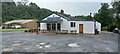
2
Whiteshiels Cafe and Caravan Park
Looking across the A7 and the valley of the Ewes Water from the start of the precipitous moorland road over to Newcastleton.
Image: © Oliver Dixon
Taken: 13 Apr 2009
0.01 miles
3
A7, Langholm
Rich in history, Langholm was the centre of the Border Reiver insurrections, Scotland's equivalent of the 'Wild West'.
Image: © Maigheach-gheal
Taken: 18 May 2008
0.06 miles
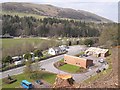
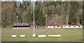
4
Langholm Rugby Football Ground
This access road is on the northeast side of the main pitch with a storage shed on the right Image] and Ewes Water Caravan and Camping Park in the background.
Image: © Walter Baxter
Taken: 20 Oct 2010
0.06 miles
5
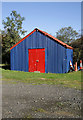
A colourful shed at Langholm Rugby Football Ground
This storage shed in the colours of the rugby club stands at the northeast corner of the main pitch.
Update Feb 2011:
I was contacted by a site visitor who had a 33 year involvement with LRFC from player to president, and he informed me that this was the old turnstile entrance to the ground prior to a bridge being demolished.
Image: © Walter Baxter
Taken: 20 Oct 2010
0.07 miles
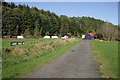
7
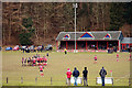
Langholm Rugby Football Ground
Langholm Rugby Football Club was founded in 1871 and is the oldest rugby club in the Borders. The ground at Milntown is half a mile north of the town on the A7. The team colours are red and the club emblem is a Scottish thistle, rugby ball and posts. April 26th 2008 will be the centenary of the Langolm Sevens.
Image: © Walter Baxter
Taken: 22 Mar 2008
0.07 miles
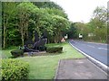
8
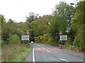
Langholm approaching
The latest edition of Langholm's relativistic road sign. Please allow the scenery to pass at 13.4ms^-1 or less. Thank you.
Image: © Richard Webb
Taken: 14 Oct 2015
0.08 miles
9
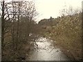
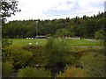
The Ewes Water flowing towards Langholm
From Whiteshiels.
Image: © James Denham
Taken: 20 Apr 2010
0.10 miles
10
Langholm Rugby Club
The rugby clubhouse and stand on the outskirts of Langholm.
Image: © Colin Kinnear
Taken: 16 Mar 2008
0.11 miles