1
Advert at St Michael's Services garage
Nith Inshore Rescue is an independent lifeboat serving the Dumfries area. We are based in Glencaple, 5 miles south of Dumfries in south-west Scotland, on the estuary of the River Nith close to where it joins the Solway Firth.
Image: © Russel Wills
Taken: 30 Sep 2021
0.02 miles
2
Post Office and shop on St Michael Street (B725), Dumfries
Showing position of Postbox No. DG1 23.
See
Image] for postbox.
Image: © JThomas
Taken: 22 May 2021
0.04 miles
3
Elizabethan postbox on St Michael Street, Dumfries
Postbox No. DG1 23.
See
Image] for context.
Image: © JThomas
Taken: 22 May 2021
0.04 miles
4
St Michael's Primary School
Originally, the school began as a Church School attached to the South Free Territorial Church. The school opened in 1865 and provided a general education - including Latin, for some pupils.
'At St Michael’s Primary we aim to provide a secure, supportive and friendly environment in which the children will develop skills and experiences, which will allow them to reach their full potential.' https://stmichaelsdumfries.dumgal.sch.uk/
Image: © Russel Wills
Taken: 30 Sep 2021
0.05 miles
5
Dumfries. The Robert Burns Mausoleum
Image: © Bill Henderson
Taken: Unknown
0.06 miles
6
Sign for Greens public house, Dumfries
Image: © JThomas
Taken: 22 May 2021
0.07 miles
7
Greens public house, Dumfries
On St Michael Street (B725).
Image: © JThomas
Taken: 22 May 2021
0.07 miles
8
Titanic Memorial, Dumfries
Titanic Memorial in Dock Park (Port of Dumfries) commemorates two natives of Dumfries who were employed by the White Star Line; a steward and a musician band who died at the sinking of the Titanic on the night of 14 April 1912.
Image: © Chris Newman
Taken: 27 Mar 2008
0.07 miles
9
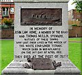
Inscription on the Titanic Memorial, Dock Park
The entire memorial is shown in this photo by another Geograph contributor
Image .
The back of the plinth is inscribed "Erected by the people of Dumfries and Maxwelltown at home and abroad". In 1912 Dumfries and Maxwelltown were two separate burghs, they amalgamated in 1929 http://futuremuseum.co.uk/Collection.aspx/the_burgh_of_maxwelltown/Description .
Image: © Rose and Trev Clough
Taken: 9 Jun 2012
0.08 miles
10
Memorial to Crew of the Titanic
To John Law Hume and Thomas Mullin local men.
Image: © Billy McCrorie
Taken: 17 Apr 2017
0.08 miles


