IMAGES TAKEN NEAR TO
Plumdon Road, ANNAN, DG12 6SJ
Introduction
This page details the photographs taken nearby to Plumdon Road, DG12 6SJ by members of the Geograph project.
The Geograph project started in 2005 with the aim of publishing, organising and preserving representative images for every square kilometre of Great Britain, Ireland and the Isle of Man.

There are currently over 7.5m images from over14,400 individuals and you can help contribute to the project by visiting https://www.geograph.org.uk
Image Map
Images are licensed for reuse under creativecommons.org/licenses/by-sa/2.0
Notes
- Clicking on the map will re-center to the selected point.
- The higher the marker number, the further away the image location is from the centre of the postcode.
Image Listing (1 Images Found)
Images are licensed for reuse under creativecommons.org/licenses/by-sa/2.0
Image
Details
Distance
1
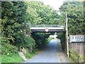
Rail overbridge on the old Solway Junction Railway
The Solway Junction Railway linked Brayton on the Maryport and Carlisle Railway with Kirtlebridge on the Caledonian Railway Main Line. Opened in 1869, this section was closed in 1921 when the Solway Viaduct was closed to traffic. It is not certain what current use is made of the trackbed over the bridge which crosses Seafield Road.
Image: © Oliver Dixon
Taken: 2 Sep 2013
0.21 miles